BOTANY, VOLUME 4: ECOLOGY - 2007
15. THE VEGETATION OF THE EARTH
15.2. Biomes of the Earth
Biomes typical of specific climate zones (zonobiomes) encircle the entire globe at characteristic latitudes. Within any given latitudinal zone, a distinction is made between humid (wet, high precipitation), semiarid (periodically dry), and arid (very dry, minimal precipitation) zones. Across all these zones, which vary in Temperature and moisture, mountain biomes or orobiomes are found. The latitudinal zonality of biomes—determined by temperature and humidity (rather than day length or seasonal shifts)—corresponds to altitudinal zonation in mountains (Figs. 15.6, 15.7). In the mountains of the humid tropics, one can traverse all the humid temperature Zones of the Earth over a short distance. However, due to differences in seasonal weather variations (such as the risk of frost), the vegetation zones correspond only very roughly to them. This "compression" of natural zones in tropical mountains explains their high biodiversity, because when viewed on a global macro-scale, all altitudinal belts merge. Individual zones (altitudinal belts), however, are no richer in species than anywhere else (see endpapers).
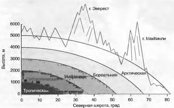
Class="center">Fig. 15.6. Comparing only humid regions reveals how plant and climate zones shift in a similar manner across both geographical latitude and altitude above sea level. Tropical high mountains, extending from the lowland tropical rainforest belt to the nival zone, serve as the baseline example. An altitude of 1 km corresponds to a latitudinal distance of about 2,000 km, while a vertical climb of 4 km from the forest line to the alpine zone corresponds to a latitudinal span of nearly 8,000 km from the equator to the polar tree line (which in Europe lies at 68–70° N).

Fig. 15.7. Temperature conditions (geographical latitude) and moisture levels shape the Earth's vegetation: A, B — humid and semiarid tropics; C, D — humid and semiarid subtropics; E, F — humid (oceanic) and semiarid (continental) temperate zone; G — boreal and subarctic zone
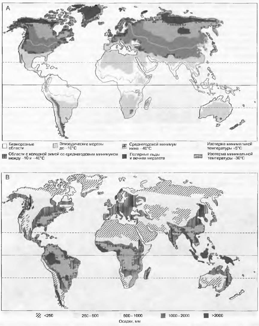
In the following sections, 16 biomes will be examined; their distribution largely corresponds to temperature conditions and precipitation levels across the continents (Fig. 15.8).
Although mountain biomes occur in all climatic zones, we will focus only on those belonging to the temperate and subtropical-tropical zones (in each case, montane and alpine belts). The biomes described here correspond to the following designations of Heinrich Walter's "zonobiomes": zonobiome (ZB) I = 15.2.1, 2, 3; ZB II = 4, 5; ZB III = 6; ZB IV = 7; ZB V = 8; ZB VI = 9, 10, 11; ZB VII = 12, 13; ZB VIII = 14; ZB IX = 15. The Examples presented here include coastal marine vegetation only to a limited extent (covered in Section 15.2.16) for ZBs I, II, IV, and VI.
Fig. 15.8. Global distribution of two critical meteorological factors that shape the Earth's vegetation cover: A — maximum air cooling (frosts); B — total annual precipitation. Mountain ranges and the crucial factor of seasonal precipitation patterns were not taken into account.
15.2.1. Tropical Lowland Humid Forests
Forests of superhumid lowlands near the equator (currently still covering 16–17 million km2, which is nearly half of all closed forests and about 11% of the Earth's land surface) are far from the monotonous wastelands rain forests are commonly and mistakenly believed to be. Significant differences exist among them, both floristically, climatically, and pedologically. There are three major tropical humid regions: northern South America with Amazonia, western Central Africa (the Congo basin and adjacent coast), and Southeast Asia (southern India, Malaysia and the Malay Archipelago, New Guinea, and northern Australia).

The tropical zone (situated between the two tropics) is a frost-free region (see Fig. 15.6) representing an enormous climatic and phytogeographical area, as is immediately apparent from the overall spherical geometry of the Earth. Constantly humid regions occupy only their inner portion, lying roughly within ±10° of the equator, or the core zone. The mean annual temperature here ranges between 24 and 30 °C, and total annual precipitation varies from 2,000 to 4,000 mm depending on the region. In a climate lacking distinct seasons, even a brief dry spell exerts stress on epiphytes (triggering succulence, CAM gas exchange, and desiccation tolerance) and serves as a crucial cue to synchronize flowering among individuals of the same species. Cyclical climatic phenomena, such as the El Niño Southern Oscillation (recurring every 3 to 7 years, typically 5), can cause prolonged droughts even in Southeast Asia (alongside catastrophic rainfall on the western coast of South America).
Warmth and high humidity promote nutrient cycling in the soil to such an extent that humus barely begins to accumulate, and soils are strongly leached (forming oxisols, red-brown lateritic soils, or quartz-sand soils). Mineral reserves in tropical rain forests are stored primarily in the plant biomass (up to 90% of the ecosystem's total potassium pool), which accounts for the devastating consequences of clearing these forests by burning. Mineral nutrients accumulated over millennia through the biological cycle are instantly mineralized and washed away by rains. Under natural conditions, minerals from plant litter are immediately bound by microorganisms and mycorrhizal Fungi and taken up by plant roots (a closed nutrient cycle; hence the forest remains exceptionally well-nourished despite the soil containing almost no nutrients). Only negligible amounts of minerals are lost via hydrological leaching, whereas a constant long-distance input is maintained by wind-blown dust; it has been proven that dust reaches the Amazon basin even from the Sahara.
Canopy Structure: tree crowns are located at heights of 30 to 50 m, forming, together with epiphytes (species of Bromeliaceae, Orchidaceae, and Polypodiophyta), a sparse upper stratum, beneath which lie subdominant tree species or young trees. Below this is a shrub layer (e.g., Piper), a layer of large herbs (e.g., Musa, Heliconia), and ground-floor species. Lianas (twining, tendril-climbing, ROOT-climbing; see Table 4.1) permeate the entire arboreal layer. Some lianas ("stranglers") grow so vigorously over their host trees after reaching the canopy that they eventually kill them and become independent plants (typical of the genus Ficus). Epiphylls (Algae, mosses, Lichens) colonize the leaves. Tropical virgin forests form a mosaic of stands at various stages of succession (Color Table 15.1). Their regeneration heavily depends on lianas and epiphytes, under whose weight trees eventually collapse. Fresh canopy gaps are colonized by fast-growing pioneer species (Cecropia, Ochroma [balsa wood], Musanga, Macaranga). Trees in later successional stages have life spans comparable to those in the temperate zone (150–200 years). Buttress roots are frequently formed
at the Base of the trunk (plank roots, adventitious stilt roots in palms). Leaves in the upper canopy are slightly coriaceous (and very long-lived as an adaptation to nutrient competition), mostly elliptic and entire-margined, and their mass flush of growth is often so explosive that they initially appear limp and reddish, looking underdeveloped ("shivering foliage"), which catches herbivores off guard. Many tropical species suffer irreversible damage even at low positive temperatures (<7 °C) ("chilling injury," see 13.3.1). Ultimately, however, the decisive ecological factor is competition for light.
Important pantropical families include Araceae (e.g., Monstera), Arecaceae (palms), Araliaceae (Schefflera), Bignoniaceae, Caesalpiniaceae, Lauraceae, Moraceae (Ficus), Piperaceae, and Zingiberaceae, among others. Typical of the paleotropical realm are Dipterocarpaceae (dipterocarps, bearing two-winged fruits) and Pandanaceae (screw pines); the neotropics are characterized by Bromeliaceae (Tillandsia). A single hectare may harbor 60 to 100 tree species (with a record of 300 in Peru), two-thirds of which are represented by single individuals. Such high species richness is attributed to the absence of past large-scale disturbances (glaciations, prolonged droughts), the lack of a frost period, the great antiquity of the ecosystems themselves, and their originally vast, partially contiguous ranges.
15.2.2. Tropical Montane Humid Forests
Between 1,000–1,800 m and 3,000–4,000 m above sea level lies the zone of tropical montane forests (also referred to as montane rain forests, elfin forests, or cloud forests) (Color Table 15.2). At these elevations, moisture supply is even more abundant because evaporation is lower for the same amount of precipitation. Almost daily in the morning, these forests enter the zone of convective Condensation (with fogs starting at 1,800 m) where they remain until late afternoon, or they are continuously swept by trade-wind clouds. At their lower boundary, near the transition to lowland forests, they reach heights of 45 m, which on sufficiently high mountains drops to 3–5 m between 3,600 and 4,000 m (krummholz / dwarf forest zone).
The mean annual temperature at an altitude of 2,000 m is about 17 °C (roughly comparable to July averages in Central Europe), dropping to about 11 °C at 3,000 m, and reaching only 6 °C at the upper timberline. Mild frosts become possible starting at 2,500 m, though they are very rare; they occur more frequently above 3,000 m, and almost every night above 4,000 m (see 15.2.3). Precipitation in the lower belt of montane forests exceeds 2,000 mm, which, given very low evaporation rates, far surpasses plant requirements. This creates a high risk of slope erosion, making a well-developed vegetation cover essential for soil protection at these elevations. Above the condensation zone, precipitation decreases, but this rarely results in a biologically significant moisture deficit.
With increasing altitude, a thick layer of coarse humus and moder develops, containing large amounts of nutrients that are not directly available to plants. Cooler conditions and prolonged waterlogging slow down litter decomposition, which in turn inhibits undergrowth development and forest regeneration. Roots partially emerge onto The surface of the soil, and their associated mycorrhizal fungi penetrate the freshly fallen leaves (a shortened nutrient recycling loop).
The combination of permanent waterlogging and a complete absence of frost in the lower montane belts results in structural similarities to lowland forests, with differences being primarily floristic. Mid-altitudes (1,800–2,500 m) exhibit the highest density of luxuriant epiphytes. In the upper belt, epiphytic vascular plants are largely replaced by cryptogams. Liana diversity decreases with altitude, vertical stratification gradually fades, and eventually only a layer of low trees or tall shrubs remains, forming a closed canopy with a sparse understory. The regression of montane forests within their natural range is closely tied to human activity. In most cases, the timberline has been pushed down by several hundred meters. High-altitude relict forests (found mostly on fire-resistant rocky sites with no other unique microclimatic traits) indicate that forests are capable of surviving at altitudes around 4,000 m. The giant rosetted tree forms discussed in Section 15.2.3 further point to the physiological potential for trees to exist here.
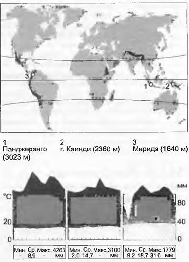
Lower tropical mountain forests are exceptionally rich in species (for example, the famous cloud forests at Rancho Grande near Valencia, Venezuela, at an altitude of 1,100 m; see V. Vareschi). At lower elevations, typical tropical families still dominate—palms, Moraceae, Rubiaceae, and others. These begin to recede at middle elevations and are entirely absent at the top. With increasing altitude, tree species from the following families become increasingly important: Fagaceae (Castanopsis in East Asia, Quercus in Central America and Southeast Asia), Nothofagaceae in New Guinea, Ericaceae (Erica in Africa, Rhododendron, Vaccinium in South and Southeast Asia), Lauraceae, and Myrsinaceae; near the timberline, Rosaceae (Polylepis in South America, Hagenia in Africa) and various Asteraceae. The prominence of conifers and tree ferns increases significantly with elevation (species of Podocarpaceae — Dacrydium, Podocarpus; tree ferns such as Cyathea), though they are patchily distributed, nowhere dominant, and mostly fail to reach the upper forest limit. In Costa Rica, the number of woody plant families (and consequently species) decreases with altitude from 82 (349 species) at 2,000 m to 34 (74 species) at 3,200 m. At the highest elevations (near the upper timberline), generally fewer than 5 species are found, with a striking increase in the prominence of Rosaceae (South America and Africa) and Ericaceae (Africa and Southeast Asia). Particularly well known are the isolated groves of Polylepis at nearly 4,000 m in the tropical Andes, which correspond to the scrubby thickets of Hagenia (both members of the Rosaceae family) in equatorial Africa.
15.2.3. Vegetation of Tropical and Subtropical High Mountains
The natural upper limit of mountain forests and the lower limit of the treeless alpine (= Andean, = Afro-alpine) belt in the equatorial tropics lies between 3,600 and 4,000 m a.s.l., and in some subtropical areas even higher. The forest limit is significantly lower (down to 3,100 m) in high-mountain desert regions, on islands, and on certain lower mountains where summits are treeless for reasons other than temperature (e.g., Mt. Kinabalu). Most high-tropical grasslands ("páramos") are currently situated well below the potential timberline, having originated from anthropogenic activities (forest clearing for pasture).

The climate of the tropical high mountains features a fluctuating diurnal regime with regular nocturnal frosts year-round, and mean monthly temperatures in the lower part ranging from 5 to 7 °C. Subtropical high mountains exhibit seasonal temperature variations, featuring frosty winters with little or no snow, and somewhat warmer summers that also bring precipitation. Precipitation here is generally lower than in the mountain forest belt (even in super-humid regions), typically under 1,500 mm; in certain areas, particularly the southern Andes, it drops below 500 mm, whereas at equivalent elevations in cloud-trapped regions of Southeast Asia, it exceeds 3,000 mm (e.g., Mt. Wilhelm in New Guinea).
Soils beneath closed vegetation in humid regions are waterlogged and black. In drier areas with sparser vegetation, weakly developed, primitive soils (gravelly-silty-loamy or sandy) are most common. Contrary to earlier assumptions, plants growing here barely receive enough moisture to cover their physiological deficit unless annual precipitation exceeds 350 mm. The thinning of vegetation in such areas (leaf area index noticeably below 1.0) ostensibly prevents the excessive Water depletion that would otherwise occur, though it remains unclear how community density is regulated. A major obstacle for the establishment of young plants on bare ground is the needle ice (pipkrake) that regularly forms at night in the uppermost centimeters of the soil profile.
The dominant vegetation type consists of grasslands interspersed with scattered, branched shrubs, the so-called "páramo." In the humid Regions of the equatorial tropics, robust tussock grasses dominate, whereas in drier areas, rhizomatous grasses form clonal "garlands" (giving way to nearly pure stands of low shrubs, known as "puna," in the very dry, more southerly interior Andes). A remarkable feature of tropical (though not subtropical) high mountains is the convergent evolution of giant rosettes. These caulirosette plants (color pl. 15.3) often take on an arboreal appearance: in Africa, these include Dendrosenecio (Asteraceae) and Lobelia (Lobeliaceae); in the Andes, Espeletia (Asteraceae) and Puya (Bromeliaceae); and in Hawaii, Argyroxiphium (Asteraceae). Such tree-like species can reach heights of up to 6 m. Leaf rosettes may close at night (protecting the apical growing zone from radiative cooling), while the dead leaf bases of young specimens insulate the moisture contained within the stem against nighttime freezing. However, since older specimens survive without this protection, its necessity appears questionable. The leaf tunic is also interpreted as protection against scorching. The crown rosettes of Asteraceae are typically densely white-woolly and share many similarities with the pubescent, candle-like plants of the genera Lupinus (Andes) and Saussurea (Himalayas). Dense pubescence protects against radiation and wetting, although many tropical and subtropical high-mountain plants thrive without such defenses. The internal Tissues of plants are well shielded from ultraviolet radiation by protective compounds (such as Flavonoids) abundantly present in the epidermis. Many tropical alpine plants protect themselves against freezing through supercooling (see 13.3). Cushion plants are surprisingly rare and play a minor role only in certain PARTS OF THE southern Andes (e.g., Azorella, Apiaceae) [and in the mountains of Ethiopia (Helichrysum species, Asteraceae) — Ed.], which is attributed to the low wind exposure in tropical and subtropical high-mountain environments.
The floristic composition of vegetation exhibits greater similarity across the world's high mountains the higher their elevation. The most significant role in closed communities across all high mountains, including tropical and subtropical ones, is played by the families Poaceae and Asteraceae. Representatives of the genera Festuca, Poa, Carex, Gentiana/Gentianella, and Senecio occur everywhere, along with closely related genera of the Ericaceae family (e.g., Vaccinium/Gaultheria/Pernettya). Among low shrubs, the genus Hypericum plays an important role (Africa, Andes), whereas in the southern Himalayas and Indonesia, similar ecological niches are occupied by Rhododendron species.
15.2.4. Tropical Semi-Evergreen Forests
Along the margins of the tropics, precipitation is distinctly seasonal, which dictates the seasonal character of the vegetation (rain-green forests, monsoon forests, dry forests). The alternation of rainy and dry seasons leads to periodic leaf shedding. Seasonally green tropical forests, if undisturbed, would dominate a significant portion of the planet (potentially covering 42% of all tropical forest area, or about 7 million km2). Local orographic shielding of forests in the tropics can lead to The formation of dry forests. Savannas, which exhibit similar climatic rhythms, are described in Section 15.2.5.

A climate characterized by periodic fluctuations in moisture arises from the seasonal shifts in thermal conditions on either side of the equator. During the northern summer, the equatorial rain belt shifts northward, and during the southern summer, southward. This astronomical forcing is intensified in certain regions by associated atmospheric Circulation patterns; moisture-laden air masses moving poleward are deflected eastward (trade winds). Temperature and pressure gradients between the cool sea and the vast, scorching interior of Asia drive moisture transport landward during the northern summer (monsoons). The onset (around June) and intensity of the monsoon season vary, yielding significant ecological and economic consequences. The "winter" half-year is dry or entirely arid. With even distribution, annual precipitation totals would often be quite sufficient even for evergreen forests. In some regions, annual precipitation hovers around 1,500 mm, but given the high atmospheric evaporation rates at these latitudes, only dry forests can survive. Mean annual temperatures in the lowlands match those of super-humid tropics (24–30 °C), but with increasing distance from the equator, they become strictly seasonal (dry periods are cooler, wet periods warmer).
Soils form under METABOLISM/18.html">The Influence of a characteristic alternation between excessive moisture and extreme dryness; however, outside of alluvial deposits, they largely consist of heavily leached oxisols, much like those in the hyper-humid central tropics. As aridity increases, the water-holding capacity of the soils becomes increasingly critical. Sandy and primitive soils vastly exacerbate drought stress (e.g., the caatinga in Venezuela). A hardpan layer (ferruginous, siliceous, or calcareous) is frequently present. Because the majority of the plant community sheds its leaves by the onset of the dry season—and because litter decomposition by normal microbial activity cannot keep pace before the next rains begin—termites and fire play an increasingly vital role in organic matter mineralization as dryness intensifies.
Characterizing this biome uniformly is impossible because a full spectrum of transitions—from moist tropical forest to arid thorn scrub—often coexists in close proximity. The Nature of a specific forest is determined by the duration of the dry season and The amount of precipitation. With increasing drought duration, tree height decreases, epiphytes and lianas disappear, and the differentiation of phenological rhythms becomes more pronounced. Leaf shedding occurs in several stages: some deciduous species drop their leaves early and consistently (e.g., Bombacaceae), while other species shed them later or sometimes retain them altogether. In many monsoon forests, the understory remains green year-round. Flowering almost invariably coincides with the rainy season, yet distinct flowering spectra exist for each phase of the annual cycle. Some species flower even in the middle of the dry season. Plant roots can extend to depths of 30 m or more. Today, human activity threatens tropical semi-evergreen forests even more severely than tropical rainforests, and their area has drastically shrunk. Their high flammability during the dry season greatly facilitates land clearing. Furthermore, large expanses of these potential forest lands are located in densely populated regions (e.g., India, the fringes of the African tropics).
Species diversity in tropical semi-evergreen forests is remarkably high—driven by a multitude of functionally diverse species groups—and in some cases even surpasses that of super-humid regions (color pl. 15.4). THE SPECTRUM OF dominant families varies by region. In South America, these include bottle-tree Bombacaceae (Chorisia), followed by Burseraceae, Bignoniaceae (Tabebuia), and Anacardiaceae (Gran Chaco — Schinopsis = quebracho tree). In Southeast Asia, monsoon forests feature Verbenaceae (Tectona grandis = teak), Dipterocarpaceae (Shorea robusta), and Combretaceae (Terminalia sp.). In Africa, for instance, in the xeric "miombo" woodlands—at late successional stages—we find Caesalpiniaceae (Julbernardia, Brachystegia), and at early stages, Terminalia.
15.2.5. Tropical Savannas
The Earth's savanna biome (covering about 15 million km2) resembles tropical semi-evergreen forests in its water-regime-driven seasonal rhythm. However, under the combined influence of climate, soils, fire, and wildlife, a distinct vegetation type has developed here, consisting of grasslands interspersed with open woodlands, dense thickets, and gallery forests along watercourses (color pl. 15.5). In the Southern Hemisphere, savannas dominate from the tropics to the southern edge of the subtropics, occupying their largest expanses in Africa. Analogous vegetation formations include the llanos of the Orinoco, the cerrados and parts of the Gran Chaco plains in Brazil, and the Paraná basin, as well as northern Australia.

The savanna climate is an even drier variant of the seasonal semi-evergreen forest climate (see 15.2.4), but annual precipitation here is typically below 1,500 mm—sometimes under 1,000 mm—and exhibits greater interannual Variability, which cannot be captured on a climadiagram. When precipitation falls below 500 mm, savannas give way to semideserts. In Africa, due to the presence of the uplifted ancient Gondwanan platform, frosts can occur on the southern margins of the region. Night temperatures throughout the winter half-year consistently remain below 10 °C.
The Nature of the soil cover and the associated mosaic of savanna vegetation are largely determined by microtopography. In southern Africa, regular alternations between elevated flat ridges and depressions (often differing in height by one or several meters) create a mosaic of (1) dry, nutrient-poor, heavily weathered, and acidic soils on the uplands; (2) moister, loamy, nutrient-rich soils in the hollows, with pH values up to 9 and above; and (3) fully leached sands on the slopes where seepage water emerges along the upper edge of clayey depressions (known as a seepage line or seepline) or above a lateritic hardpan. In the Brazilian cerrados, the Venezuelan and Colombian llanos, and the savannas of northern Australia, a similarly fine-grained soil mosaic—varying in moisture and crusting intensity (known as "arrecife" in South America)—shapes local species richness and vegetation. Termites and fire play a major role in nutrient cycling.
African savannas are sparse woodlands that, in the absence of fires and the pressures of herds of elephants and large ungulates, would quickly "scrub over." Localized destruction of trees by elephants opens up the ecosystem, creating foraging opportunities for browsers (such as impalas) and grazers (zebras, wildebeest). This, in turn, suppresses tree regeneration while simultaneously providing conditions for grass fires, which ultimately maintain the savanna landscape. The more abundant the grasses, the more frequent the fires (every 2–3 years, but often annually) and the fewer opportunities trees have to grow. Natural fires in savannas release roughly 1.4 gigatons (= 109 t) of carbon into the atmosphere each year—a significantly larger amount of CO2 than is emitted by tropical (0.5) and all other (0.2) forests combined (in the case of savannas, this is part of the natural carbon cycle, whereas for tropical forests, it represents a net loss emitted into atmospheric currents). Because of fires, soils lack a litter layer, leading to more intense crusting, which impedes rainwater infiltration and increases surface runoff. Ungulate population sizes (governed by food availability, rainfall, and apex predators such as lions and leopards) regulate the balance between woodlands and grasslands. Fires were accidentally ignited by early hominids perhaps more than 1 million years ago. Ill-conceived fire suppression—stemming from a misunderstanding of conservation objectives—along with Interference in predator-prey dynamics, can destabilize the balance between open grasslands and closed dry forests in this fragile system.
Setting aside the floristically rich gallery forests, three main components characterize African savannas: in the plains and depressions, C4 grasses (such as Pennisetum) and heavily armed acacia species (Mimosaceae); and on the uplands, various Combretaceae (Combretum species with characteristic four-winged fruits). Important elements of the llanos include Curatella, Byrsonima, and others; in the Chaco region, Prosopis, Aspidosperma, Schinopsis, and palms of the genus Copernicia; and in northern Australia, evergreen Eucalyptus species and unarmed Acacia species possessing phyllodes instead of bipinnate leaves (or leafless ones). Also typical of Australia are convergent tree forms with succulent trunks, such as Brachychyton (Sterculiaceae); in Africa, Adansonia (baobab, Bombacaceae); in both Africa and Socotra, Dracaena (dragon tree, Dracaenaceae); and in South America, Chorisia (Bombacaceae, see 15.2.4).
15.2.6. Vegetation of Hot Deserts
In both hemispheres, between the tropics and the temperate zone (or the Mediterranean winter-rain region), lie vast arid zones known as deserts and semideserts. Their existence is driven by equatorward-bound returning air currents that, during their descent, lift equatorial rain clouds toward the zenith and desiccate the air masses (see Fig. 12.7). Geographically, these regions encompass the deserts of Mexico and Arizona (Sonora), the semideserts of southwestern Brazil and northwestern Argentina, the Sahara and Arabian deserts, parts of northwestern India and Pakistan, the Karoo in southern Africa, and the arid expanses of Central Australia. Special arid zones formed by cold coastal currents occur in southern Peru and northern Chile (Atacama) and in southwestern Africa (Namib).

These arid subtropical regions receive from 0 (Atacama) to approximately 250 mm of precipitation per year. In certain regions, frequent seasonal rains occur, such as in the southern part of the Sahara during the northern summer or in the northern part of the southern hemisphere's desert zone, also in summer, but they rarely exceed 100 mm. Climatological evidence indicates that the almost complete destruction of tropical forests in western Africa resulted from the advance of dry vortices from the southern Sahara. The Sonoran Desert lies at the intersection of monsoon (summer) and Mediterranean (winter) precipitation regimes. The temperature regime here is strongly seasonal: summers are very hot, while winter temperatures are low, with possible frosts.
Soils are very poorly developed or primitive. Due to constant desiccation, their surface layer is enriched with alkali metal salts (or gypsum), leading to the formation of highly alkaline (pH>10) soils, especially in depressions. Based on the substrate character, the Sahara is traditionally subdivided into the following types: rocky deserts (hammadas), gravelly-pebbly deserts (regs), and sandy deserts (ergs), as well as Various Forms of saline deserts ranging up to completely vegetation-free salt crusts (sabkhas, saline depressions). Intensified economic activity in adjacent coastal areas can lead to anthropogenic desertification (the Sahel syndrome). A crucial factor is the groundwater table depth. The presence of trees in the middle of the desert indicates groundwater outflows, with roots capable of reaching depths of >50 m (e.g., Prosopis in the Neotropical realm, Acacia in Africa; see Table 13.3 in Section 13.7.5.1).
Depending on moisture availability, the vegetation cover of the desert region ranges from an almost complete absence in lichen deserts or ephemeral vegetation (short-lived annuals that appear only during seasons with good rainfall) to sparse mimosoid low woodlands (reaching a maximum height of up to 8 m, composed of tall shrubs of Prosopis or Acacia species), and—where groundwater tables are high—to oases with tamarisk (Tamarix) and date palm (Phoenix) forests. Regarding biomass as a whole, the most critical components are low-growing woody forms (shrubs) with very deep root systems (col. tab. 15.6); depending on the groundwater level, these are either periodically deciduous (many Mimosaceae) or evergreen forms—such as species of the genus Larrea (creosote bush, Zygophyllaceae family), distributed from North America (L. tridentata) to South America (L. divaricata). These specific desert plants do not experience unavoidable stress; their presence is a consequence of moisture deficit (otherwise, other plants would grow here). Severe community thinning and phenological rhythms adapted to specific conditions are regulated by the water regime. In their active state, these plants assimilate and transpire, in some cases, even more than their counterparts in humid regions. Succulents, whose existence is sustained by internal moisture reserves (found only in relatively shallow-rooted plants), are restricted rather to the wetter areas of this arid region. The largest realm of succulents is located in the deserts of Mexico and Arizona, where precipitation is very sparse but falls regularly (see above). Therophytes and geophytes also play a significant role, greening and flowering only after rainfall, along with clonally spreading grasses in sandy deserts (e.g., Aristida pungens, a grass from the Sahara).
Floristically, this desert zone is rather poor. The ubiquitous presence of Mimosaceae (Acacia, Prosopis, Cercidium), Zygophyllaceae (caltrops—Larrea, Zygophyllum), Solanaceae (Lycium), and, where salinity is present, Chenopodiaceae (Atriplex, Suaeda) is striking. A peculiar curiosity is the ancient plant Welwitschia mirabilis, which grows in the Namib Desert (see Fig. 11.211). Among succulents, an unusual convergence is observed between stem succulents of the Cactaceae family in the Neotropical realm and Euphorbiaceae in the Paleotropical realm, and analogously between leaf succulents of Agavaceae and Asphodelaceae (Liliales, Aloe sp.). Both Cactaceae (e.g., Carnegiea, Cereus) and Euphorbiaceae (Euphorbia sp.) are represented by woody plants up to 10 m tall. In South Africa, There is a great diversity of stem succulents from the Asclepiadaceae family (Ceropegia, Stapelia, etc.) and leaf succulents from Aizoaceae (Mesembryanthemum, ice plant, Lithops, living stones).
15.2.7. Region of Winter-Green Forests with a Mediterranean Climate
The region bordering temperate and subtropical climates corresponds to the Mediterranean-type climate and is characterized by evergreen sclerophyllous vegetation. This climatic zone is most pronounced in the Mediterranean region, with analogous zones found in California and Chile, the Cape region, and Australia.
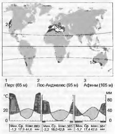
In summer, this zone falls within the dry subtropical belt, which shifts poleward; in winter, it enters the temperate climate zone driven by westerly winds. Annual precipitation ranges between 400 and 1,100 mm (typically 500–800 mm), with the majority falling in the Mediterranean between November and February. In winter at sea level, frosts down to -6 °C are possible (in the north down to -14 °C, causing the death of olives in Tuscany). Summer temperatures regularly reach 35 °C and above. The western Mediterranean still experiences Atlantic influence, whereas the eastern Mediterranean (Greece, Turkey, the Levant countries) is more continental (precipitation is lower here, and summer temperatures are higher).
Wind systems determine the climate of these regions—for instance, the cold, gusty easterly winds in the northern Adriatic that frequently bring summer rains (bora), as well as the dry, hot, very gusty northerly winds in the eastern Mediterranean (etesians) blowing in mid-summer, which create countercurrents to the Southwest Asian monsoons (the Mediterranean climate is often referred to as an etesian climate).
On alluvial deposits of lowlands, buried chemically weathered soils are frequent. They belong to the group of brown soils (cambisols) or parabrown soils (luvisols formed from clay deposits, see 12.5.2.3), and over limestones, they are colored red (so-called terra rossa). Also common are weakly developed humus soils lying directly on bedrock substrates (rendzinas and rankers). Plant survival during the dry period is facilitated by deep-penetrating cracks in rocks containing fine-earth material (roots reach >20 m in depth).
This vegetation type is characterized by dense, long-lived leaves ("sclerophylly"). Without any proven causal connection, they are often termed xeromorphic (i.e., caused by dryness), although sclerophyllous leaves occur in plants across every climatic zone, even in the Arctic. Rather, sclerophylly is associated with leaf longevity, strong herbivore pressure, and nutrient supply (and indirectly with soil moisture as well), see 13.6.3. The sclerophylly of the Western Australian scrub is also attributed to nutrient deficiency (especially phosphorus). The presence of summer-green species (in the Mediterranean, Fraxinus ornus, Paliurus spina-christi, etc.) confirms that this type can function despite dryness. In the Mediterranean regions of the Northern Hemisphere, climax vegetation would be represented by evergreen oak forests (Quercus agrifolia in California, Q. ilex in Europe). Due to high (40–100 year) fire frequencies (partially caused by anthropogenic factors), conditions here strongly favored The Development of pyrophytic pine species (Pinus). With fires recurring more frequently than every 40 years, sclerophyllous shrub communities develop (maquis in the Mediterranean, chaparral in California, matorral in Chile, fynbos in the Cape region), which occurs mainly due to their ability to regenerate via stump sprouts. Proximity to populated areas is associated with deliberate winter fires repeated at short intervals ("prescribed burning" in California). Maquis, serving as the "floristic heir" of tertiary laurisilva vegetation (see 15.2.8), flourishes most luxuriantly in moist areas and on northern slopes. However, because precisely these areas were selected for pastures and arable land, a false impression is created that maquis is typical only of dry rocky and stony sites. Its further degradation leads to the formation of open low-shrub heathlands—garrigue, or, in the eastern Mediterranean, cushion-like dwarf shrub communities—phrygana (resulting from fires occurring at intervals of <10 years or intensive grazing).
From a floristic standpoint, the vegetation of Mediterranean climate regions ranks among the richest on Earth. Numerous winter annuals (especially Asteraceae, Poaceae, Fabaceae), geophytes (in the Mediterranean, Orchidaceae, Iridaceae, Liliaceae), large perennial herbs (in the Mediterranean, e.g., Salvia) and grasses, low shrubs (in the Mediterranean, Cistus, various brooms, such Lamiaceae representatives as Thymus, Rosmarinus; diverse Ericaceae), and lianas (in the Mediterranean, Asparagus, Smilax) thrive in these confined spaces; fragments of beech forests up to 10 m tall also occur—in the Mediterranean with Quercus, Juniperus, Laurus, Pistacia (Anacardiaceae), Arbutus (Ericaceae), Rhamnus, Myrtus, and wild Olea; in California with Quercus, Adenostoma (Rosaceae), Ceanothus (Rhamnaceae), Rhus (Anacardiaceae), Arctostaphylos (Ericaceae); in Chile with such Lauraceae as Beilschmiedia and Persea alongside Anacardiaceae; in the Cape region with Ericaceae; and in Australia with Banksia, Hakea (Proteaceae), and Mimosaceae (col. tab. 15.7). Across most of southwestern and southeastern Australia, this vegetation type is represented by eucalyptus woodlands with Leptospermum, Callistemon, etc. (all Myrtaceae) (col. tab. 15.7).
15.2.8. Laurel Forest Zone
The laurel forest zone (laurisilva), which during the Tertiary period formed a major, globe-spanning biome, has currently drastically contracted under anthropogenic influence and is restricted to small, relict, disjunct patches that nevertheless occur worldwide. It comprises evergreen forests existing across a broad range of frost-free humid regions from the northern boundaries of modern subtropics to the temperate zone. They are located at the same latitudes as Mediterranean regions, but in areas lacking a pronounced dry period and featuring a relatively narrow annual temperature amplitude. In the subtropics, laurel forests typically occur in mountains above 1,400 up to 2,000 m above sea level.
The laurel forest zone is typified by a climate approaching humid, with annual precipitation of 1,000–2,000 (up to 6,000) mm. Frosts are virtually absent (winter minimum temperatures do not drop below -2 °C, and the absolute multi-year minimum has never fallen below -10 °C); simultaneously, considering the biome's distribution across nearly 25 degrees of latitude, mean monthly temperatures range from rather low values in the north to high values in the subtropics.

The combination of moderate mean annual temperatures and high precipitation corresponds to humic, sometimes nearly peaty soils with a thick leaf-litter layer. A well-developed silty-loamy metamorphic horizon of intrastratal clay formation is present. The soils are actively cultivated.
Laurisily (Laurel-leavedness) is a collective concept associated not only with specific climatic conditions. The term characterizes leaves as "rigid, oval, and entire-margined" occurring under the climatic conditions described above, with this leaf type being exclusive to a specific forest type within such a climate zone. In almost all parts of the world, it is also characteristic of specific conifer species. Laurel forests can attain heights exceeding 40 m (coastal redwood forests of California, Valdivian rainforests in Chile, eucalyptus forests of southwestern Australia, Southeast Asian Castanopsis forests, and mixed Nothofagus and Dacrydium forests of southwestern New Zealand). Frequently, they represent surviving relict patches, yet they are still no less than 25 m tall. These are invariably very dense stands with a sparse understory. The cool-temperate outposts of this zone are the rainforests of windward coasts on the Olympic Peninsula near Seattle (USA) and western Tasmania (col. tab. 15.8).
The floristic composition of laurel forests is represented primarily by angiosperms, especially species of the Lauraceae family and representatives of other families within the order Laurales, as well as Magnoliaceae and Aquifoliaceae (with the genus Ilex), which occur with high constancy but low Abundance. Leading species of Southeast Asian laurel forests belong to the genus Castanopsis; in New Zealand, Tasmania, and Chile, evergreen trees of the genus Nothofagus (southern beech) dominate, while in Tasmania and Chile Eucryphia—a representative of its own primitive family within the Rosidae—is also present, underlining the ancient connections of the Southern Hemisphere landmasses. In the perhumid climatic zones of southern coastal Australia, eucalyptus dominates, whereas in Florida, evergreen forests consist of southern live oak (Quercus virginiana) alongside significant participation of Lauraceae (Persea) and Magnoliaceae. Citrus fruits also originate from the Southeast Asian laurel forests; the natural habitats of these Rutaceae representatives have never been definitively established. Characteristic conifers growing under this damp, mild climate include Sequoia sempervirens in California, Fitzroya and Araucaria in Chile, species of the Podocarpaceae family in the foothills of the Drakensberg in South Africa, Dacrydium (Podocarpaceae) in New Zealand, Phyllocladus in Tasmania, and Cryptomeria in Japan. The laurel forests of the Canary Islands are a recent relict of Central European ones. The occurrence of sweet bay (Laurus nobilis) as part of the Mediterranean maquis points to its Tertiary past. In the understory of Pontic deciduous forests (northern Anatolia), laurel-leaved Rhododendron ponticum and Prunus laurocerasus occur naturally—both are successfully cultivated in Western Europe. Laurel-leaved mountain forests on the southern slopes of the Himalayas (Nepal) indicate ancient west-east connections of this biome. In recent decades, many laurel-leaved species have been "escaping" from gardens in the southern Mediterranean and spreading in the wild. For instance, on the northern shore of Lago Maggiore (Ticino canton, Switzerland), a laurel-type forest with tall (up to 25 m) camphor trees (Cinnamomum), bay laurel, and fan palms (Trachycarpus from East Asia) has formed under the canopy of Castanea in modern times. Rhododendron ponticum became established in southern England and Ireland quite some time ago and is spreading there, becoming a nuisance; the consequences of introducing Myrica faya from the Canary Island laurel forests into Metrosideros forests of the Hawaiian archipelago (introduced alongside nitrogen-fixing symbionts) are already nearly catastrophic.
15.2.9. Temperate Deciduous Forests
The typical vegetation of the humid temperate latitudes of the Northern Hemisphere (the "nemoral" zone) comprises deciduous, summer-green forests; in the Southern Hemisphere, there are only small patches of this forest type, namely deciduous southern beech (Nothofagus) forests. The highest species diversity is found in such forests in East Asia (China, Korea, Japan) and along the eastern coast of North America. The third major forest area, Central Europe, is comparatively poor in species composition (see 15.11.1), which stems from their periodic displacement during glacial times, combined with the barrier role played by the Alps and Carpathians upon their return.
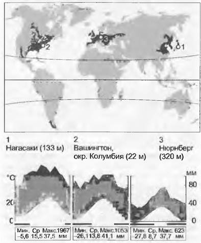
Climatically, the lowland areas of this zone are characterized by a growing season lasting from 5 to 8 months (with mean daily temperatures exceeding +10 °C for 4–6 months), a rather long cold period (<0 °C, with frosts down to -25 °C), and a summer precipitation maximum. Mean annual temperatures range between 5 and 15 °C, and mean annual precipitation between 500 and 1,000 mm.
The prevailing soil type is mildly acidic brown forest soils (cambisols) with metamorphic horizons of varying thickness, forming primarily on loesses. Their most developed and thickest variants have been transformed almost without exception by human activity, so that modern forests of this type frequently survive on such marginal soil variants as rendzinas or rankers. Most deciduous forests in eastern North America currently grow on soils that were withdrawn from agricultural use 50–150 years ago. The annually deposited leaf litter decomposes completely within 1–1.5 (2) years, making the formation of mor humus rare (with the exception of acidic soils under forests dominated by Quercus and Castanea); conversely, the formation of mull or moder humus types is typical.
Cool-temperate deciduous forests reach a mature height of 30 — 35 m and are relatively open (with a leaf area index of about 5), which allows their understory to support a fairly diverse assemblage of herbaceous plants and shrubs. They also harbor certain evergreen species, such as representatives of the genus Ilex, which occur in nearly all deciduous forest regions. The understory flora is predominantly composed of spring-active species (many of them geophytes), whose life cycle is largely confined to the period before the trees and shrubs fully leaf out. An exception is found in the deciduous forests of East Asia, which feature a bamboo understory so dense that other plant species are unable to grow there. A major survival challenge for tree seedlings is being buried annually under a layer of leaves up to 5 times the natural thickness of a single leaf. Consequently, late-successional species possess significantly larger seeds (and more vigorous seedlings). Roughly half of the species in these forests are wind
-pollinated. The timing of leaf unfolding and, even more markedly, leaf shedding (which enables these forests to withstand freezing temperatures and avoid snow load) is regulated by Photoperiodism, thereby minimizing damage from late and early frosts.
Overall, the most important genus in this vegetation type, representing the highest number of species, is the oak (Quercus). Species of the genera Acer, Fagus, Tilia, Betula, and Prunus are also widely distributed across all deciduous forest regions. Eastern North America harbors several tree genera absent in Europe, such as Carya (hickory, Juglandaceae, col. pl. 15.9), Liriodendron (tulip tree, Magnoliaceae), Liquidambar (Hamamelidaceae), and Diospyros (persimmon, Ebenaceae). In East Asia, particularly in the temperate regions of northern and central China, all genera native to Europe are present, but with greater species diversity. Many ornamental trees and shrubs cultivated in Europe, such as roughly 200 species of azaleas (summer-green species of the genus Rhododendron), originate from these East Asian forests. Conifers, when present, almost invariably belong to Pinus species, and in extremely arid areas also to the genera Juniperus and Sabina (for example, in northeastern China). Genera such as Aesculus and Platanus, which occur naturally in Europe but are restricted to its southeastern parts, further highlight the significant affinity among these three deciduous forest zones. Riparian species of Salix, Alnus, and Populus are likewise characteristic of all three regions. The East Asian and European regions are connected by a narrow belt of mountain forests that are floristically similar to both at the generic level, extending along the southern foothills and slopes of the Himalayas, the Hindu Kush, and the Caucasus (in Nepal, for instance, at elevations between 2,300 and 2,800 m a.s.l., composed of Carpinus, Acer, and Betula species).
15.2.10. Temperate Mountain Forests
Along with the tropical and subtropical biomes already discussed (see 15.2.2/3), this and the following section examine a second group of mountain biomes (orobiomes) characteristic of the temperate zone (including the high mountains bordering the Mediterranean region). Temperate mountain forests, which occur between 1,000 — 1,500 m and 2,000 — 3,500 m above sea level depending on latitude, occupy smaller areas than lowland forests; however, they support floristically extremely rich mixed conifer-broadleaf forests at lower elevations and pure coniferous forests at higher ones.
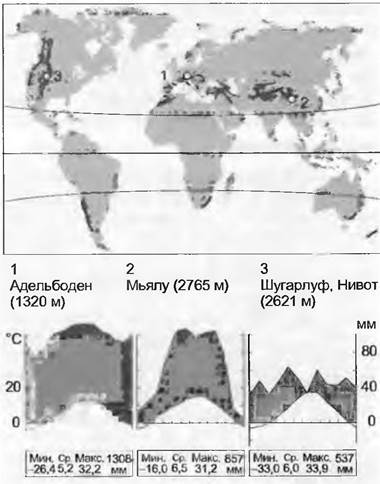
It is difficult to provide a single climatic characterization for this zone, which represents a transition from lowland temperate forests (see 15.2.9, 15.2.12) to a moderate-alpine climate, owing to its wide range of climates—from warm to moderately cold and from oceanic to continental—as well as a large elevation span ranging from 1,000 to 2,000 m. Overall, with few exceptions in continental areas, moisture conditions in these forests are quite favorable, while mean monthly growing-season temperatures are lower than in adjacent lowlands, fluctuating between 7 and 12 °C (compared to 12 and 18 °C in the lowlands). The growing season lasts from 3 to 6 months; winters are typically snowy and cold (though in continental regions, due to temperature inversion, not necessarily colder than in the valleys), with frosts occurring for 6 — 12 months depending on elevation.
With increasing elevation, soils become progressively more humic and acidic. The general altitudinal trend shifts from brown forest soils in deep valleys to podzols at higher elevations, with the latter restricted to humid and moderately cold sites. Thick layers of litter and raw humus are typical of the upper belt.
These mountain forests are remarkably diverse. For instance, in North America, within the mountains of California, grow the world's largest trees, Sequoiadendron giganteum (mighty giant sequoias with trunk diameters up to 7 m, heights of 100 m, and ages of 2,000 years) at elevations of about 1,500 m a.s.l., as well as presumably the world's oldest trees, Pinus aristata (= P. longaeva, bristlecone pine, at 3,500 m a.s.l.). However, the potential for regeneration from trunk fragments or, in some species, from stump sprouts—meaning genetically identical material—makes the question of the "oldest" trees debatable. Forests dominated by Abies, Picea, and Pinus occur in the mountains throughout the Holarctic realm. In the northwestern United States (e.g., Mount Rainier) and locally in the humid mountains of northeastern Asia near the timberline (e.g., Mount Fuji), the dominant species belong to the genus Tsuga, which became extinct in Europe during the glaciations. In arid zones, these are joined by mountain forests of Juniperus and Cupressus (Cascade Range, Atlas Mountains, high-elevation areas of the Mediterranean, Karakoram, Tibet). In the temperate-mountain belts of the Southern Hemisphere, conifers are rare (Phyllocladus and Arthrotaxis in Tasmania, representatives of the genus Podocarpus in southeastern Australia, Austrocedrus in Chile). Deciduous trees in Holarctic mountain forests are represented by the genera Betula, Sorbus, Alnus, and Populus, and additionally by Crataegus in Asia; in the Southern Hemisphere, the subantarctic zone features representatives of the genus Nothofagus (both evergreen and deciduous), alongside frost-hardy Eucalyptus species in Australia. Among the tallest trees on Earth (> 110 m) is Eucalyptus regnans (mountain ash), which grows on mountain slopes along the southern edge of the Snowy Mountains (col. pl. 15.10).
Mountain forests are critically important for protecting lower-lying areas by mitigating erosion and, in heavy-snow regions, preventing avalanches. In many places, the timberline is receding due to logging and land clearance for pasture (see 15.2.2). Worldwide, temperate mountain forests reach their natural limits at elevations where mean annual temperatures drop below 6 — 7 °C (exceptions include slopes with loose scree substrates, avalanche tracks, or regions with an extremely oceanic climate where forest limits lie lower). Because winter temperatures at the timberline vary dramatically across the globe, they play a less decisive role. Other climatic factors make it easier to define the upper limit of mountain forests: it runs approximately + 100 m in elevation above the seasonal (summer) 6 — 7 °C isotherm. The tree life-form is closely tied to the macroclimate; consequently, only shorter statured plants capable of producing their own (warmer) microclimate are presumed able to exist beyond these lower temperature boundaries.
15.2.11. Alpine Vegetation of High Mountains in the Temperate Zone
Although high-elevation areas situated above the natural timberline (the alpine orobiome) cover only about 3 % of the Earth's land surface, their flora comprises roughly 4 % of all flowering plant species. The major mountain systems of the temperate zone include the Rocky Mountains and the Sierra Nevada in California, the Cascade Range, the Alps, the Carpathians, the Caucasus, the northern Hindu Kush and Himalayas with their eastward extension into Korea, the mountains of Central Asia, Japan, the Andes south of 35°, the Drakensberg in South Africa, the Snowy Mountains in Australia, Cradle Mountain in Tasmania, and the Southern Alps of New Zealand—together accounting for nearly half of the Earth's alpine regions. In botanical geography, the accepted term "alpine" denotes a Location "situated above the timberline,"signifying a more specific meaning than the broader definition of "mountainous."
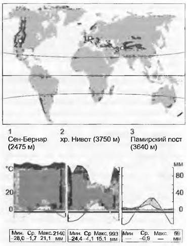
Mean temperatures in the near-surface air layer or in the region of underground Meristems during the short (6 to 16 weeks) growing season range from 5 to 10 °C, rising to 20 °C at noon on sunny days. Meteorological station data fail to capture crucial microclimatic situations. Thanks to their low stature and compact life forms, plants avoid the cold during the growing season, at least during daytime hours (morphological adaptations for capturing solar heat). For sites where thorough repeat measurements have been conducted, it has been proven that the moisture deficit commonly assumed for alpine plants is entirely negligible; it may exist only in the very arid regions of the Pamirs and parts of the Southern Andes (a local exception being rocky outcrops with a thin layer of fine earth). Precipitation totals (along with mean annual temperatures) provide little information about actual living conditions in this belt, as it remains inactive for long periods due to cold conditions. Thanks to snowmelt and summer rains, almost the entire annual precipitation total becomes available to plants throughout the short growth period.
In the lower part of the alpine belt (especially in the presence of dwarf shrubs and tussock grasses), humus soils with a very thick layer of raw humus predominate due to reduced decomposition rates. Periodic surface drying of the soils can temporarily inhibit mineralization processes and reduce nutrient availability. With increasing elevation, unstructured primitive soils become increasingly common. Cryogenic processes and mechanical soil erosion caused by slope steepness assume major importance. Beneath the rubble or debris, a surprisingly high amount of moisture is sometimes retained. Soil stability, and consequently the protection of lower-lying areas, depends heavily on the vegetation cover of the alpine belt.
By definition treeless, alpine vegetation (grouping together the alpine and subalpine belts proper) consists mainly of (1) dwarf shrubs, (2) clone-forming graminoids (grasses and sedges), (3) perennial, often also clone-forming, rosette-forming herbaceous plants, (4) cushion plants in the broad sense (forming mats, flat cushions, or hemispherical cushions), and (5) cryptogams (mosses and lichens). Rosette plants and cryptogams achieve the greatest diversity (col. pl. 15.11). Geophytes and annuals are very scarce or entirely absent (except in areas bordering the subtropics or the Mediterranean region). Morphological, phenological, and physiological adaptations are so strongly developed that the productivity of closed alpine vegetation, calculated per month (!) of active growth, matches that of all other humid biomes, including the lowland tropics (see Fig. 13.39). The only significant limitation here is the duration of the active growth period; therefore, the plants forming this biome are by no means more stunted than those in other biomes. Freezing temperatures occurring during the winter dormancy period play no significant role. Only early summer late frosts and early autumn frosts are of critical importance, though they never pose a substantial threat, resulting merely in partial leaf loss and seed shedding. Vegetative Reproduction is very widespread.
In the temperate zone, the most significant families in the alpine belt are Asteraceae, Poaceae, Cyperaceae, Caryophyllaceae, Ericaceae, Gentianaceae, Rosaceae, and Ranunculaceae. The first four typically account for more than 50% of local floras. In various regions, Saxifragaceae, Primulaceae, Campanulaceae, Polygonaceae, and Scrophulariaceae play an important role. High mountains, much like oceanic islands, are largely isolated from one another and are therefore rich in local endemics. The flora of the Alps comprises about 650 species of flowering plants with an alpine distribution type, with about 150 species ascending above 3,000 m. The world record belongs to Saussurea gnaphalodes, growing at an altitude of 6,400 m in the Everest massif.
15.2.12. Steppes and Prairies
Vast grasslands develop in the continental regions of the temperate zone. Aside from climate, these ecosystems are shaped by regionally operating factors such as ungulates and fire, and in part also by humans. In addition to the Eurasian steppes and North American prairies (and the vegetation of the Great Basin), similar vegetation forms are also found in Argentina (the pampas), the warm-temperate south of Africa, and the Atlas Mountains, as well as fragmentarily in temperate Australia and on the leeward side of New Zealand's South Island.
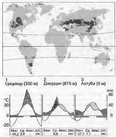
Mean annual climate data (average totals) reveal very little about the living conditions within this biome. In the interior parts of large continental landmasses of the Northern Hemisphere between 35° and 55° latitude, winters are sometimes extremely cold (down to -50 °C), whereas summers are extremely hot (often > 40 °C). Soil moisture reserves during the growing season are derived from melting winter snow, spring-dominant rainfall, and, in wetter regions, summer thunderstorms (annual precipitation totals range between 250 and 500 mm).
Soils develop primarily on loess, loess-like loams, or sands, and frequently feature a very deep profile. Since the majority of primary plant production remains underground (amounting to 2/3 in grasslands), a deep humus profile forms, often darkly colored (black earths, chernozemes). Burrowing rodents (hamsters, prairie dogs) facilitate the mixing of soil horizons.
Broadly speaking, four vegetation types are distinguished within this climatic zone: (1) grassland communities under 50 cm in height—comprising shortgrass prairies, typical steppes, and the mountain steppes of Mongolia (arid and cold regions); (2) grassland communities over 1 m in height, formed by robust tussock grasses—comprising tallgrass prairies, the pampas, and South African "prairies" (wetter regions with a milder climate); (3) sagebrush steppes, dominated by dwarf shrubs of the genus Artemisia that are woody at the base or throughout (especially in the cold regions of the Great Basin and Central Asia); on the plateaus of Central and Western Asia, these are replaced by (4) thorny cushion communities (Astragalus, Acantholimon, Noaea) (col. pl. 15.12). Many of these continental arid regions lie at considerable elevations, which explains the low air temperatures despite relatively southern latitudes. The shortgrass prairies of Wyoming and Montana, as well as the Great Basin, lie at an altitude of about 2,000 m, the Mongolian steppes at 2,500 m, and the temperate region of South Africa (west of the Drakensberg) at 1,600 m. Because favorable soil and climate conditions are well-suited for grain cultivation and pastoral farming (the "Wild West"), natural steppes and prairies have now almost completely vanished. However, grazing by ungulates (such as bison herds) also constituted a natural disturbance factor. Portions of the continental grasslands could climatically support forests (regions with annual precipitation >400 mm), but tree growth there was prevented, just as in savannas, by natural fires sparked by lightning. The growth meristem of grasses is protected by many centimeters of overlying soil. The initial impact of ungulates here is not as substantial as in savannas. Tussock grasses, such as those in the tallgrass prairies and the pampas, can likewise inhibit tree growth through strong competition.
A characteristic grass genus of steppes, and partly also of shortgrass prairies, is Stipa (feather grass). Stipa still occurs today in arid habitats of Central Europe (e.g., Kaiserstuhl, Valais, Vinschgau, Wachau) as a relict of the cold, precipitation-poor periglacial fringes of the glacial periods, with its western distributional limit located in the Pannonian region. Stipa tenacissima (alfa grass) dominates the steppes of the Atlas Mountains. In shortgrass prairies, Bouteloua gracilis (Blue Grama) plays an important role. In North American tallgrass prairies, C4 grasses belonging to the genera Andropogon, Sorghastrum, and others dominate (in the south-central US, Kansas is typified by an abundance of very decorative dicotyledonous plants such as Echinacea and Rudbeckia); Hyparrhenia and Pennisetum dominate in South Africa, and Cortaderia in the Argentine pampas. Over much of western North America, Artemisia tridentata prevails; A. sieberi replaces grasses in the arid parts of Central Asia. The continental arid region of Western Asia is also the homeland of wheat, barley, and rye, while the southern foothill regions of the Central Asian steppes are THE ORIGIN OF pome and stone fruit trees of the Rosaceae family (apple, apricot; Almaty is the "city of apples").
15.2.13. Deserts of the Temperate Zone
Deserts and semi-deserts also occur in the temperate zone. Winters are frosty, and summer precipitation is extremely low. This is typically exacerbated by severe soil salinity, creating extremely extreme survival conditions at the same latitudes where oceanic-climate beech forests develop. The boundaries with subtropical arid regions are very gradual. For instance, the Mojave Valley includes the Mojave Desert, where topographic positioning results in very cold winters. Although the desert lies on the edge of Death Valley in northeastern California—a depression situated below sea level and one of the hottest places on Earth during the summer—it is classified as a temperate, winter-cold type of desert. The vegetation around the Caspian Sea corresponds to that of all major salt lakes. Temperate semi-deserts are found in the lowlands of Central Asia, the Gobi, and certain interior valleys of the Hindu Kush, while in the Southern Hemisphere, they occur in Patagonia and partially in southern Australia (col. pl. 15.13).

The climate of this zone shares a very similar temperature regime with the grasslands described above (see 15.2.12), albeit with higher maximum summer temperatures and precipitation below 250 mm (less than 60 mm in the Taklamakan Desert of Central Asia, and less than 100 mm in the Gobi Desert). Soils, as in other arid regions, are weakly developed. Where salinization takes effect, extremely alkaline soils are formed—solonchaks (saline or gypsiferous soils) and solonetzes (sodic soils, see 12.5.2.3). High gypsum content in the soil can lead to the formation of hard, water-impermeable layers that are nearly impenetrable to plant roots. Excess salinity or gypsification always occurs when prolonged evaporation (driven by the upward movement of soil moisture) exceeds precipitation.
The vegetation of this semi-arid to arid region with cold winters ranges from relatively diverse combinations of species and life forms, as seen in the Mojave Desert or in edaphically determined (sand) island deserts of southern Australia, to succulent halophytes that form single-species communities. With few exceptions (such as on slopes), soil salinity plays a significant role throughout. Halophytes dominate the majority of this zone by area. The Mojave is widely known for its semi-succulent, "crested" candelabra-like Joshua trees (Yucca brevifolia), but it also features a rich representation of frost-tolerant Opuntia species, dwarf shrubs, annual grasses, and forbs. The plateaus surrounding the central part of Death Valley—with its scorching summer soils (absolute maximum 56 °C in the shade, with daily temperatures consistently exceeding 45 °C)—are dominated by Atriplex shrubs (their leaves are covered in salt secretions, making them white and highly reflective to heat). For the same reason, many species exhibit dense white-woolly pubescence on their leaves (e.g., the asteraceous Encelia farinosa). As on sea coasts, the vegetation surrounding saline depressions exhibits varying degrees of Salt Tolerance depending on distance from the center. For example, around large salt lakes, the abundance of moderately salt-tolerant dwarf shrubs and herbaceous perennials—belonging mainly to the Asteraceae family (Utah; the same situation surrounds the Caspian and Aral Seas)—gradually decreases until, on openly exposed crystalline salt (arguably the most hostile habitat for life on Earth), only a single species survives: Suaeda depressa (characterized by CAM Photosynthesis, active salt excretion, and Cell sap Osmotic Pressure of up to 7 MPa). The soils of gypsum deserts, such as those in central Kazakhstan, are chemically less aggressive (despite a pH of 11), but they present mechanical barriers that restrict access to groundwater. Only a few plants occasionally manage to pierce the impermeable layer located 1–2 m below the surface. The vegetation of this zone consists predominantly of partially woody shrubs (though saxaul "forests" near Lake Balkhash reach heights of 12 m, though they are usually no higher than 3 m). The Central European outpost of halophytic vegetation of saline steppes is located in the Pannonian lowland plain (e.g., on the eastern shore of Lake Neusiedl).
Floristically, this is the simplest part of the zonobiome, as a single family—namely Chenopodiaceae (Atriplex, Suaeda, Salicornia, etc.)—dominates everywhere. In certain regions, representatives of Zygophyllaceae, Solanaceae, Polygonaceae, and Asteraceae also play a role. Outside saline areas, the flora is richer, and in warmer regions, the species spectrum approaches that of subtropical arid areas (see 15.2.6).
15.2.14. Boreal Forests
The boreal ("northern") part of the temperate zone encompasses a broad belt across the entire Holarctic, dominated by coniferous forests ("taiga"). These cover the forested region of northern Europe (Scandinavia, northern Russia), Siberia, Canada, and Alaska, reaching the Arctic Circle and in places extending beyond it (in Eastern Siberia up to nearly 73° N).

In this zone, humidity also varies significantly along a gradient from the marine coast to inland areas, but due to the short growing season (3–5 months) and generally low temperatures, it is rarely a limiting factor here. Extremely low winter temperatures are common (reaching -70 °C in Siberia), while summers can be hot or even sweltering.
Soils vary from humus-rich brown forest soils and podzols (light-colored soils with an eluvial horizon) to bog soils and weakly developed ranker and rendzina soils. Primitive soils on sands also become overgrown with forest. Slowly decomposing needle litter contributes to an acidic soil reaction. The presence of permafrost in the soil precludes the development of closed forest stands, and a feedback loop exists between soil temperature and forest cover. As the forest closes upon permafrost thawing, it in turn contributes to lowering the soil temperature (heat-bringing solar radiation no longer reaches the soil), causing the permafrost to rise again and trees to die off, whereupon the Sun once more begins to warm the soil more intensely, and so on. A minor water level surplus of just a few centimeters can be a decisive factor in forest establishment. Consequently, even slight topographical fluctuations appear significant to the naked eye (forest does not grow in waterlogged, stagnant depressions).
Severe winter frosts preclude the growth of most deciduous tree species in boreal forests. Notably, however, it is precisely in extremely cold regions that summer-green larch dominates, occasionally forming single-species stands. Typical boreal forests are more open than temperate forests because in most cases they remain undisturbed, featuring abundant standing deadwood with dead trees remaining upright for decades. Periodic fires (occurring once every 200–300 years) play a major role in natural forest development cycles. In recent decades, fire frequency in the Canadian taiga has increased markedly in connection with global climate warming. As the northern tree line is approached, trees become more tapered and the intervals between them widen. Indeed, at the forest boundary in certain regions, coniferous forests are replaced by low-growing birch stands (birch forest-tundra). Coniferous trees frequently branch at ground level and taper, which—combined with low solar angles and the prevailing open canopy—facilitates more complete light utilization; the snow cover becomes thinner, which positively influences soil warming (and consequently tree root conditions). A dense moss layer beneath the trees can trap nutrients, causing the forest to experience "nutrient starvation" (in this case, The impact of fires is beneficial). Tree Nutrition is aided by the development of ectomycorrhizae (with agaric fungi). Developing undergrowth is occasionally subjected to heavy browsing pressure by animals during the winter. Due to its wide distribution, this forest biome is an important climatic factor: because of its low albedo (reflectivity), it absorbs more solar radiation than treeless, snow-covered white landscapes in winter. Furthermore, it stores vast amounts of carbon in its timber and humus layer; 40% of all timber from these forests is used for paper production, making them critically endangered.
Dominant genera in boreal forests include Picea, Pinus, and Abies, alongside Larix in certain regions (col. pl. 15.14). Pinus sylvestris dominates in western northern Scandinavia, but the distribution range of Picea obovata (a subspecies of P. abies with smaller cones) begins as early as eastern Finland. In North America, its ecological equivalent is Picea glauca. Abies balsamea in North America corresponds to A. sibirica in Siberia. Under generally unfavorable soil conditions, Pinus successfully prevails. Larix dominates primarily in Eastern Siberia ("light-conifer" taiga formed by L. dahurica and others, replaced in North America by L. laricina). The most important deciduous companion genera of the boreal taiga are Betula, Populus (P. tremula, European aspen; P. tremuloides, American aspen), Salix, and 15.2.15. In the lower ground layer, apart from mosses and lichens, dwarf shrubs—mainly of the genus Vaccinium—predominate.
15.2.15. Subarctic and Arctic Vegetation
While only 2 native vascular plant species have been discovered in Antarctica and the ice-free area is extremely small, the circumpolar botanical-geographical belt of the Northern Hemisphere located north of the tree line covers 5% of the Earth's land surface and Supports nearly 1,000 species of angiosperms. The closed plant cover of the Subarctic is called tundra (between 62° and 75° N; in Europe and Greenland, the Influence of the Gulf Stream pushes it 5–7° further north than in eastern North America). This term is derived from the Finnish word "tunturi", which designates treeless hilly terrain. In higher latitudes, vegetation is highly fragmented and restricted to favorable microhabitats (up to 83° N).
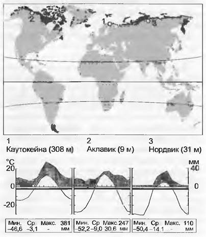
The climate of the arctic biome is characterized by a short growing season lasting 6–16 weeks, the major part of which coincides with the 24-hour polar day. During this period, temperatures in the southern part of the tundra can rise up to 20 °C. The snow cover formed during the long winter is very shallow because total annual precipitation is low (<400 mm), resulting in the deep penetration of arctic cold into the soil. Despite low precipitation totals, the arctic biome is damp (with few exceptions) due to very low evaporation rates. Moreover, permafrost impedes moisture drainage into the soil in many places (see below). Local moisture redistribution is closely linked to snow drifting and topography.
Cold, stagnant moisture, and the resulting retardation of decomposition processes leave a distinct imprint on arctic soils. They are frequently waterlogged, highly acidic, and habitable only by specialized plants (Ericaceae, Cyperaceae). Soil cover structure is shaped by freeze-thaw processes (solifluction, patterned ground, frost heaving). The vegetation mosaic is determined by topography and associated stagnant moisture. Well-drained soils on sloping terrain foster an increase in species richness and productivity. Where soils thaw deeply in summer, a corresponding plant cover develops.
The main forms of arctic vegetation are: (1) dwarf-shrub tundra, (2) sedge and cottongrass tundra, (3) bogs/mires, (4) open higher-plant communities on primitive soils, and (5) bryophyte and lichen vegetation (col. pl. 15.15). At the southern boundary of the tundra, open birch (or larch) forest-tundra occurs in certain areas, transitioning into boreal forests. Almost all plants in this biome are capable of vegetative propagation (clone formation). Spore-producing plants (mosses and lichens) play an essential role throughout the vegetation cover, forming the ground layer. In the High Arctic, primitive soils are covered by a crust of cryptogamic plants with a high proportion of blue-green algae. Associations with soil microorganisms (sedges) and symbioses with fungi (ericoid mycorrhizae) play a major role in supplying plants with nutrients. In predominantly acidic soils, nitrogen is sourced not only from ammonium but also from free Amino Acids. The presence of a long photoperiod somewhat compensates for the brevity of the growing season. Because plant phenorhythms are largely regulated photoperiodically, warm weather alone cannot replace the actual duration of illumination over the year. Numerous studies conducted in the alpine belt have demonstrated that low temperatures during the growing season do not limit growth as is frequently assumed; the limiting factor is the duration of the period itself.
The flora of the subarctic and arctic zones is relatively poor (<1/10 of the species Diversity of the entire alpine flora). This diversity is concentrated mainly in small, topographically defined patches free from stagnant moisture. When the surface is flat and wet as well, species diversity drops sharply, with the majority of primary production being generated by fewer than 100 species. The most prominent families are Ericaceae (especially the genera Vaccinium and Empetrum), Cyperaceae (Carex, Eriophorum), and Salicaceae (Salix). Other important families include Betulaceae (Betula nana), Rosaceae (Rubus), and Poaceae (Deschampsia, etc.). The most important moss genera are Sphagnum and Hylocomium, while fruticose lichens belonging to the genera Cladina, Cladonia, and Cetraria are widespread. The arcto-alpine flora shows great similarity to the flora of the temperate alpine belt (sharing species such as Ranunculus glacialis and Oxyria digyna), yet it is inappropriate to apply the term "tundra" to alpine vegetation.
15.2.16. Coastal Vegetation
Coastal vegetation exhibits both zonal and azonal features. Zonal forms typical of a given climate are significantly more widespread in their characteristic latitudes than other zonal vegetation types. The climate is very maritime. Coastal plants are exposed to substantially smaller temperature amplitudes, and winters within the very broad temperate zone are almost always frost-free.
In all cases, this vegetation is subject to salinity and mechanical factors (wind, flooding, soil instability). Plants of steep coasts must be extremely salt-tolerant, residing in the zone of constant sea spray exposure, as pure salt deposits remain after evaporation. Sand dunes, which might appear intensely heated and extremely dry, are actually often far from dry. Large-pored sand impedes the capillary rise of moisture, preserving it in deeper layers that plant roots successfully reach. The strong transpirational cooling and self-shading by plants made possible by these processes prevent excessive surface heating of the sand and associated damage. To protect leaves from overheating in such sun-baked habitats, many plants utilize: (1) very narrow leaves (ensuring effective thermal exchange with the air); (2) reflective upper leaf surfaces (pubescence with woolly or peltate hairs, see Fig. 13.10); or (3) upward-oriented leaf blades that track THE POSITION OF the Sun, as seen, for example, in the currently widespread Hydrocotyle bonariensis (see below). Plants of muddy-clayey tidal flats must be adapted to surviving under oxygen-depleted (anaerobic) root conditions, which—combined with direct exposure to salty seawater under intense sunlight—leads to the evolution of diverse adaptations characteristic of mangrove vegetation (see below).
Overall, all coastal plants are subjected to mechanical stress from storms, wave action, and/or unstable substrate. This explains why clonal life forms and wind-resistant leaves are so frequently encountered here. Seeds and fruits also possess specialized adaptations, as vividly illustrated by The structure of the coconut. Enclosed within the three-layered protective husk of the hard fruit—the leathery exocarp, the fibrous buoyant mesocarp, and the waterproof hard endocarp—lies a large seed with a lipid-rich, waterproof endosperm (copra) and a liquid nutrient medium inside (liquid endosperm), which facilitates the germination of the embryo of this floating diasporic seed after journeys spanning thousands of kilometers across the ocean. The seedlings of Rhizophora (mangrove trees) are capable of anchoring themselves on shifting muddy-clayey shores thanks to their anchor-like roots and elongated hypocotyls.
Last update: 07/08/2026
Editorial and Educational Adaptation: This material has been compiled based on the primary/original source text. The project team performed an editorial review, corrected technical inaccuracies, structured sections, and adapted the content for an educational format.
What was processed:
- elimination of formatting defects (OCR errors, structural breaks, corrupted characters);
- editorial organization of content;
- standardization of terminology in accordance with academic sources;
- verification of factual statements against the original source text.
All mentions of the author, publication year, and origin of the primary text have been preserved in accordance with the source.