BOTANY VOLUME 4 - ECOLOGY - 2007
15. THE VEGETATION OF THE EARTH
The Earth's plant cover acts as a mirror image of climate, superimposed on regional geological conditions and existing environmental disturbances (Fig. 15.1). Because climatic conditions lack sharp geographical boundaries, there are no sharp borders between vegetation zones, either; these zones are defined by the dominance of specific life forms (so-called formations, see Fig. 14.42, Section 14.3.4). This chapter examines natural zonal vegetation, i.e., the plant cover that has developed under specific climatic conditions without human influence, while taking into account closely intertwined factors such as substrate and various types of disturbance (for an exception, see Section 15.2.16). However, this is an idealized picture, since human impact on vegetation (hunting, pastoralism, fire) has existed since ancient times, and the consequences of this prolonged Interference cannot always be fully discerned. Covering all aspects of anthropogenic impact, from shifting forest cultivation to modern agriculture, would far exceed The Scope of this chapter. For the same reasons, it will focus primarily on late successional stages, the so-called climax vegetation communities, or climax vegetation (see 14.3.2).
Class="center">Fig. 15.1. Factors influencing the distribution of the Earth's zonal vegetation. For the sake of clarity, not all interactions are shown in the diagram
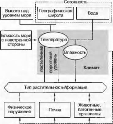
Alongside invariant conditions such as latitude and altitude, which determine Temperature regimes, atmospheric Circulation and ocean currents driving Water transport play a crucial role. Moisture availability depends not only on absolute precipitation levels, but also on The ratio of precipitation to evaporation into the atmosphere, with the latter in turn governed by temperature conditions. Latitude exerts an astronomically determined influence on seasonal temperature fluctuations, which, directly or indirectly, shape the seasonality of the water regime. In high latitudes, seasonal temperature changes are the dominant factor, whereas in lower latitudes, the water regime takes precedence. With regard to temperature, both gradual changes and threshold levels (such as frost—whether present or absent) are critical. Cold yet frost-free areas (such as certain temperate marine coasts) can support tropical species, while comparatively warmer yet continental areas prone to frosts cannot. Proximity to the sea also plays a major role. Vegetation is significantly affected by typical zonal disturbances such as tropical cyclones or fires, by large herbivorous mammals—both grazers of the herbaceous layer and browsers of shrub and tree foliage—and by zonal soil processes driven by numerous biotic and abiotic factors. Despite the multitude of environmental factors at play (see Fig. 15.1), the modern global vegetation (see endpapers) can be "predicted" based on very few parameters (primarily just temperature and precipitation) using mathematical models (such as those of A. Woodward or R. Leemans). This underscores the overriding influence of climate on vegetation (see Fig. 14.42) and opens up possibilities for future forecasting projects.
Since vegetation zones correspond to climatic zones, they are most frequently described from a climatological perspective. H. Walter defined the so-called zonal biomes, characteristic of the Earth's major climatic regions (see 15.2). Their spatial distribution varies: in some cases, their boundaries are sharply defined (e.g., the boreal coniferous forest zone), while in others they represent a collective concept, grouping together similar yet upon closer inspection highly diverse vegetation types. This Classification, presented below, is therefore a practical yet, by necessity, rather crude auxiliary tool. The first part of this chapter provides a Brief Overview of Central European vegetation, as this is the vegetation with which readers are most directly familiar. The second part describes the vegetation of the world, grouped into 9 zonal biomes, with certain zonal biomes further subdivided into altitudinal groups (montane or "orobiomes") or by degree of aridity.
15.1. Vegetation of Central Europe
The Central European floristic region can be defined as humid, cool-temperate, with cold winters; biogeographically, it extends from Ireland and northwestern Spain in the west, gradually narrowing toward the Urals (see Fig. 14.19). In the north, it encompasses the southern part of the Scandinavian Peninsula. The Alps and the Carpathians form the boundary with a different floristic region to the south (for climate, see 15.2.9).
15.1.1. From Lowlands to Lower Montane Forests
The climax Formation of the humid, cool-temperate zone is the summer-green deciduous forest (see Figs. 14.42, 15.2.9). During the growing season, which lasts 5–6 months (from late April to early October), the productivity of these deciduous forests is almost as high as that of tropical rain forests (though when averaged over the entire year, it is halved). These forests are characterized by synchronous leafing and shedding, winter-hardy buds, and an associated understory flora shaped by seasonal light fluctuations beneath the canopy. Conifers participate in or even dominate the tree stand only under continental climate conditions (especially in the northeast) and in colder mountain forests (see 15.1.2).
Prior to the era of agriculture, Central Europe was entirely forested (see Fig. 11.308). Only in the Alps, Sudetes, and Carpathians did forests have an upper climatic (temperature-determined) timberline; on the highest peaks of the Black Forest, Bohemian Forest, and Harz Mountains, one could observe a stunted zone of the "Struggle for Existence" (*Krummholz* zone), which was driven more by exposed ridge conditions than by altitude (Fig. 15.2). Climatic limitations on forest growth caused by aridity in drier and warmer landscapes were similarly absent, while wind-driven salt spray restricted forest cover only on islands and very narrow strips along the North and Baltic Sea coasts. Naturally treeless areas were restricted exclusively to locations where the soil was too shallow (and therefore excessively dry), waterlogged, or saline for tree growth. However, primeval Central European forests did not form an unbroken canopy for these reasons alone. Mosaic patches of open ground, where the modern meadow flora developed, arose from natural forest development cycles, storm damage, insect infestations, natural fires, windthrow, and grazing by large mammalian herbivores such as European bison. Despite this, the vast majority of impacts on forests are attributed to human activity, which has resulted in only about a quarter of this vast region remaining forested today (and in many cases, only as artificial plantations).
Fig. 15.2. Altitudinal vegetation belts of Central Europe along a north-south profile. Altitudinal belts rise toward the south and with increasing overall relief elevation. In the inner continental Alps, the beech disappears and spruce becomes dominant

From a floristic standpoint, the Central European region is characterized above all by the main dominants of deciduous forests: Quercus robur, Fagus sylvatica, Acer platanoides, Fraxinus excelsior, Corylus avellana, Anemone nemorosa, and many others. Close historically rooted floristic ties with other PARTS OF THE Holarctic deciduous forest belt are evident in the fact that the same or closely related species occur in the Sino-Japanese and Atlantic North American floristic regions (e.g., Fagus, see Fig. 14.17). The flora of the Central European region was severely impoverished As a result of Quaternary glaciations; the vast majority of species currently growing here were able to return during the Late Glacial or early Post-Glacial periods from southern (mostly eastern) refugia (see 11.3). This is one of the key reasons for the close floristic links with the Mediterranean (sub-Mediterranean) region (see, for example, Fig. 14.21).
The floristic Differentiation of the Central European region can be discerned precisely through the affinities of its species—whether oceanic or continental, boreal or submediterranean. This provides the basis for subdividing it into the Atlantic, sub-Atlantic, Central European, and Sarmatian provinces. At a higher rank, the Alps and Carpathians stand out as independent subregions (Alpine and Carpathian) based on their unique flora and vegetation, primarily due to their upper mountain vegetation belts (see Figs. 14.19, 15.1.2).
Characteristic species of the Atlantic province, such as Ulex europaeus, Myrica gale, Erica tetralix, Erica cinerea, Helleborus foetidus, and Ilex aquifolium (see Fig. 14.25), extend deeply into the Mediterranean region across a large portion of their ranges and can therefore be termed Atlantic-Mediterranean.
The sub-Atlantic province is characterized by species whose ranges extend further east, such as Cytisus scoparius, Lonicera periclymenum, and Digitalis purpurea. In the plant cover of the Atlantic and sub-Atlantic provinces, which feature milder winters, conifers are almost entirely absent. Here, alongside deciduous forests composed mainly of oak and birch, bogs, and meadows on nutrient-poor podzolic soils, dwarf-shrub heath communities dominated by heather (Calluna) and Atlantic Erica species play a major role in the vegetation.
The Central European province is characterized primarily by species distributed predominantly in the continental east, but whose ranges are partially restricted by the oceanic western part of Europe: Abies alba, Fagus sylvatica, Carpinus betulus, Quercus petraea, Tilia platyphyllos, Galium sylvaticum, etc.
The Sarmatian province encompasses the eastern part of the Central European region. Notable among its core species are characteristic associates of oak forests: Euonymus verrucosa, Potentilla alba, and Melampyrum nemorosum. Mixed pine-oak forests of Quercus robur and Pinus sylvestris predominate, and beech is absent. In the southeast, they partially transition into forest-steppes.
The lower-belt Central European deciduous and coniferous forests include:
(1) Beech forests and mixed forests with a significant beech component (see Fig. 15.5, D, E, F) alongside ash, sycamore maple, lime, and in the south also partially silver fir, etc. These forests predominate in the western central uplands, as well as in the lower belts of all medium-altitude mountains and in the limestone massifs of the Alps. In lowlands, they are particularly common in areas of young terminal moraines on nutrient-rich soils (Fig. 11.259).
(2) Oak-hornbeam mixed forests, which are restricted to those sites in the lower montane belt on richer soils where beech—which they normally outcompete—is at or near the edge of its distribution range (e.g., in northwestern Germany and dry interior landscapes).
(3) Thermophilous mixed oak-hardwood forests frequently cover south-facing slopes and dry, gentle mountain slopes. They harbor sub-Mediterranean species such as downy oak (Quercus pubescens), Acer monspessulanum, Cornelian cherry (Cornus mas), and numerous herbaceous plants that are dominant further south or east.
(4) On nutrient-poor, acidic soils of the lower elevations, oak forests thrive with Calluna vulgaris (heather) and other undemanding plants in the understory.
Table 15.1. A — D — humid tropical forests (A — C — Pacific coast of Panama; D — Papua New Guinea) featuring typical regeneration gaps; E, F — buttress roots provide stabilization, while lianas cause damage; G — epiphylls obscure leaf venation; H — heavy damage is caused by herbivores (in this case, leaf-cutter ants)

Table 15.2. A — mountain forest of Gynoxis, Paso de la Virgen, Ecuador, 4000 m; B — relict forest of Polylepis sericea, Mérida, Venezuela, 4050 m; C — species-rich cloud forest of Rancho Grande, northern Venezuela, 1100 m; D — fog forest, Mt. Kaindi, Papua New Guinea (fog line, 1800 m); E — fog forest of Quercus, Las Nubes, Panama, 2200 m; F — montane rain forest near Paso de la Virgen, Ecuador, 1900 m; G — Tillandsia usneoides in the fog forest of the Mérida mountains, Venezuela, 1800 m; H — tree with epiphytes in the Pasochoa montane rain forest near Quito, Ecuador, 2800 m

Table 15.3. A, B — rosette trees of Espeletia, Páramo el Ángel, northern Ecuador, 3600 m; C — woolly candle plants, here Lupinus allopecuroides, Guagua Pichincha, Quito, Ecuador, 4300 m; D — Trichocereus pasacana, Cuesta del Obispo pass, northwestern Argentina, 3050 m; E — Gentiana nevadensis near Bolívar Peak, Venezuela, 4150 m; F — páramo with Espeletia timotensis and Hypericum ericoides, Paso Águila, Venezuela, 3900 m; G — dense cushion of Azorella compacta (Apiaceae); H — clonal mats of Festuca orthophylla, Cuesta del Obispo pass, northwestern Argentina, 3900/4250 m
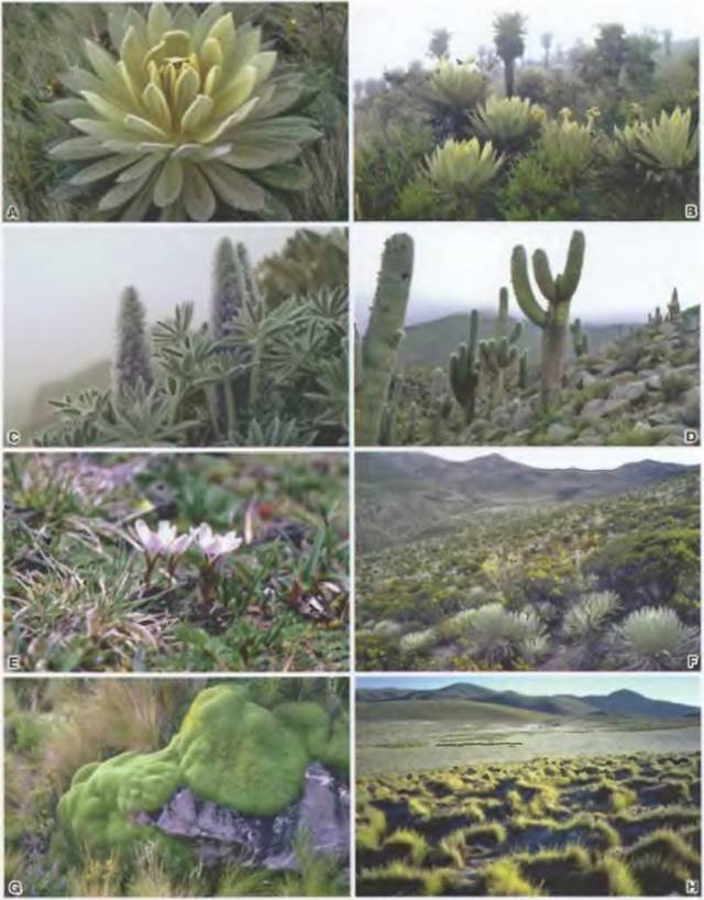
Table 15.4. The same forest in Panama during the rainy season (A) and the dry season (B); C — seasonally dry tropical forest in northern Venezuela, mass flowering of Tabebuia (Bignoniaceae); D — miombo woodland in western Zambia with Brachystegia spiciformis; E, F — dry forest in Guánica, Puerto Rico (200 rainless days): with Bursera (E), epiphytes (Tillandsia, G), succulent lianas (Vanilla, G), and cacti (H)
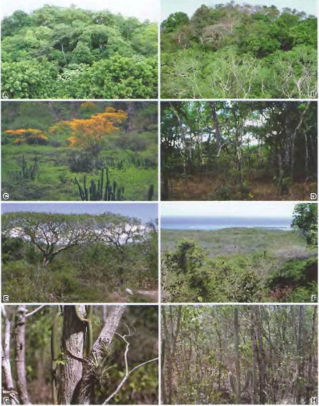
Table 15.5. A — D — various "open" savanna forms in Kruger National Park, South Africa; B — river with gallery forest; E — fruits of Combretum heterophyllum, F — Acacia tortilis; G — northern Australian savanna with termitaria; H — mulga scrub, northern Australia

Table 15.6. A, B — Larrea tridentata and Carnegiea gigantea, respectively, in the Sonoran Desert, Arizona; C — Jatropha (Euphorbiaceae) and Opuntia, northwestern Argentina; D — bottle tree Beaucarnea (Liliaceae) and columnar cactus Cephalocereus (Cactaceae), Mexico; E, F — succulent shrublands with Euphorbia canariensis in Tenerife; G — Northern Sahara with Acacia raddiana (groundwater indicator); H — sand dunes with clonal grasses

Table 15.7. A, B — maquis with Arbutus unedo (strawberry tree), Samos Island; C, D — garigue with Cistus salvifolius, Crete; E, F — one of the numerous Arctostaphylos species and chaparral in California; G — Western Australian sclerophyll bush with Banksia prionotes; H — open eucalyptus forest, southeastern Australia

Table 15.8. A, B — laurophyllous forest with Persea indica in Tenerife; C, D — laurophyllous forest with Castanopsis and Alnus in Nepal; E — semi-humid eucalyptus forest in Queensland; F — Valdivian rain forest in Chile; G, H — Podocarpus latifolius in the Gudu laurophyllous forest at the FOOT of the Drakensberg, South Africa (surrounded by fire-induced grasslands)

Table 15.9. A, B — oak-hickory forest, North Carolina; C, D — deciduous forest with Nothofagus alpina in central Chile; E, F — deciduous forest with hardy kiwi (Actinidia) in Sichuan province, western China; G, H — Central European beech-oak forest with Anemone nemorosa

Table 15.10. A, B — upper timberline forests in Australia (Snowy Mountains, 1900 m, with Eucalyptus pauciflora) and the Alps (Tyrol, 1950 m, with Pinus cembra); C, D — mixed mountain forest in central Switzerland, 1200 m, with Fagus, Acer, Abies, and Picea; E — mountain forest in Tasmania, 1100 m, with Nothofagus, Eucalyptus, Arthrotaxis, and giant rosettes of Richea (Ericaceae); F — mountain forest in Kazakhstan, Tien Shan, 1900 m, with Picea schrenkiana, Sorbus, Crataegus, and Populus; G — mountain forests in Chile (38° S) with Nothofagus and bamboo understory, 1850 m; H — Araucaria araucana, 1400 m

Table 15.11. A — cushion plants of Silene acaulis, Central Alps, 2600 m; B — dwarf shrubs of Rhododendron ferrugineum, Central Alps, 2100 m; C — alpine meadow with edelweiss (Leontopodium) and false hellebore (Veratrum), Sichuan, China, 3400 m; D — alpine meadow in the Snowy Mountains, Australia, 2100 m, Craspedia sp.; E — grass heath, Drakensberg, 3050 m, South Africa; F — dwarf-shrub and cushion heath, Cradle Mountain, 1600 m, Tasmania; G — alpine turf with Kobresia, Niwot Ridge, Rocky Mountains, 3600 m; H — mountain heath with Pinus pumila, Mt. Nurikura, 2800 m, Japan

Table 15.12. A — mountain steppe of Stipa and Leontopodium, Tien Shan, 2500 m, Central Asia; B — short-grass steppe, 2000 m, Wyoming; C, D — tall-grass prairie with Rudbeckia, 500 m, Missouri; E — sagebrush steppe of Artemisia terra-alba, 800 m, Kazakhstan; F — Patagonian steppe, 500 m, with Mulinum spinosum (Apiaceae) and Stipa speciosa (photo by O. Sala); G — sagebrush steppe of Artemisia tridentata, 2300 m, Nevada; H — alfa grass steppe, Atlas Mountains, 1500 m
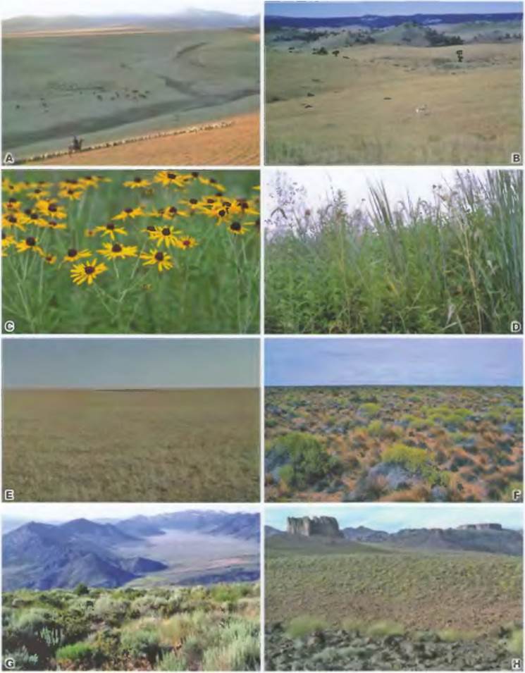
Table 15.13. A, B — Great Salt Lake with Suaeda depressa, Utah; C — Mojave Desert with Yucca brevifolia, California; D — desert with Atriplex, edge of Death Valley, Nevada; E, F — shrublands of Haloxylon aphyllum near Lake Balkhash, Central Asia; G, H — stony and sandy desert with Ephedra and the grass Aristida, Kazakhstan

Table 15.14. A — typical boreal forest with Picea obovata, northeastern Finland; B — crucial role of topography in the distribution of forest and mire, northern Sweden; C, D, F — boreal birch and willow swamp forest; E — lush tall-herb vegetation; G — fruticose Lichens; H — dry mixed birch-pine forest
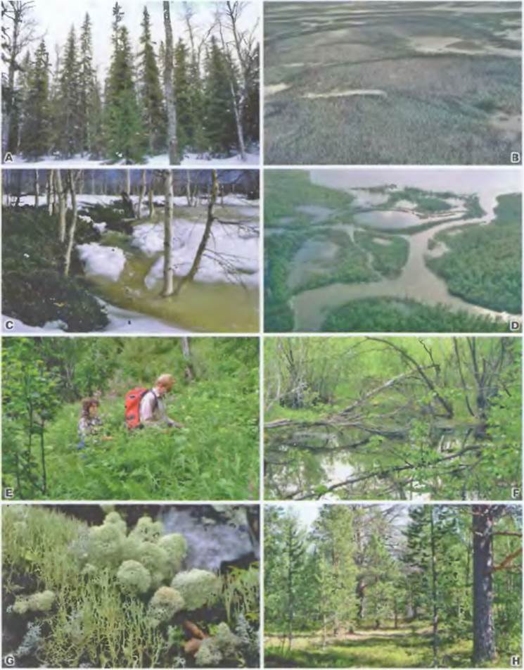
Table 15.15. A, B — fen with Eriophorum and directly adjacent (photo B) a raised palsa mire; C, D — sedge tundra beneath melting snowbed and with frost-heave hummocks, respectively; E, F — tundra with dwarf willows; G, H — Empetrum nigrum and Carex bigelowii — two dominant circumpolar species (all Examples from northern Sweden)
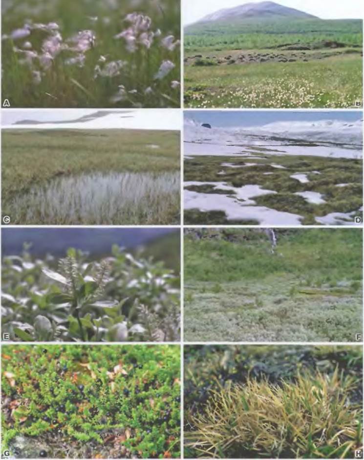
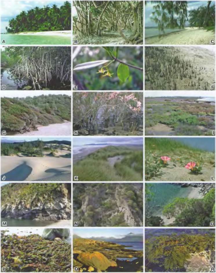
Table 15.16. A — Cocos nucífera, Caribbean coast; B, C — Pandanus and Casuarina, Great Barrier Reef; D, E — Rhizophora mangle, Florida; F — Avicennia marina, Queensland; G — wind-shaped coastal forest south of Sydney; H — lagoon with Tamarix, Greek archipelago; I — salt marsh, Camargue, southern France; J — coastal dunes and buried forest, Oregon, USA; K — dune landscape, North Sea coast; L — Convolvulus, Corsica; M — O — rocky Mediterranean coast (M, N — Ischia, O — Samos, N, O — Euphorbia dendroides); P — R — littoral zone, North Atlantic (P — various macroalgal species, R — pure stands of Fucus)
(5) In the mountains, oak and its associates ascend slightly higher than beech. Oak and mixed forests dominated by oak possess more open canopies than beech forests, resulting in a richer understory of shrubs and summer herbaceous plants. Oak is a "light-demanding tree", whereas beech is a "shade tree". The coniferous forests found here include:
(6) Pine forests (composed of Pinus sylvestris), mainly on poor, dry sandy soils of flat and rolling plains.
(7) Norway spruce (Picea abies) is common in the lowlands only in northeastern Europe; in Central Europe, it is a tree of the middle and upper montane forest belts (Fig. 15.5, A, B; 15.10, D).
(8) Floodplain forests will be discussed separately below.
Driven by flowing or standing waters, river floodplains, their hydrosere stages, swamp forests, and mires develop (cf. Fig. 14.35, 14.36, 14.41, 15.3, 15.5, G, H, I). Their ecological differentiation is based on the extent of flooding during high water, soil nutrient status, and organic matter enrichment under anaerobic conditions (peat formation). Excessive moisture can halt The Development of trees.
The biota of river floodplains, stretching along rivers and streams, must adapt to severe and irregular fluctuations in water level (cf. Fig. 14.35, 15.5, G, H). Sedimentation (alluvial deposition) and erosion constantly alter natural floodplain landscapes. Flooding exerts a negative impact on ROOT Respiration and causes mechanical damage (particularly from ice movement, shifting gravel, sand, and silt), but it also enriches floodplains with nutrient salts and organic litter products. As waters recede, exposed gravel and sandy soils can become intensely heated at the surface and dry out to a considerable depth. The intensity of these impacts decreases stepwise with declining flood levels, extending from the low-lying channel-side zone toward the flood-free high terrace at the outer edge of the floodplain (cf. vegetation zonation, cf. Fig. 14.35).
In standing waters (oxbows, backwaters), the deposition of inorganic material ceases; instead, with the accumulation of dead PLANT AND ANIMAL remains, an organogenic layer (gyttja) or peat forms, gradually reducing the water depth. As aquatic and marginal vegetation develops in accordance with water depth, a centripetal shift of individual plant communities takes place until the water surface ultimately disappears (silting-up/terrestrialization, cf. Fig. 14.36, 15.5, I). In nutrient-rich (eutrophic) standing waters, abundant plankton gives rise to a specific type of mud called gyttja, while high carbonate content can lead to The formation of white "calcareous marl"; this serves as a valuable material for climate history reconstruction, acting as a unique "climatic archive" due to its high content of plant, animal, and plankton remains.
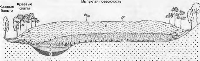
Mires refer to peat deposits and the plant cover developing upon them. Peat consists of the remains of dead mosses and vascular plants undergoing gradual carbonization in the absence of oxygen, during which their tissue Structure can be preserved for a very long time. During the overgrowth of water bodies or on waterlogged mineral soils, fens (lowland mires) are formed. Their waters are more or less nutrient-rich, and the peat formed within them typically exhibits a weakly acidic to neutral reaction (reed swamps, sedge fens, or swamp forests and carr; cf. Fig. 14.41). Under a climate characterized by high precipitation, moisture-loving peat mosses (genera Sphagnum) can develop on their surface over long periods; the dead lower parts of these mosses become waterlogged while the upper layers continuously grow upward, causing the plants originally present (including tree growth) to die off. Such highly nutrient-poor mires, which receive nutrients solely via atmospheric precipitation and dust deposition—specifically, raised bogs (Fig. 15.3, cf. Fig. 15.5, K, L)—can rise several meters above the surrounding landscape, adopting a convex, watch-Glass-like shape. Around the periphery of their elevated surface lie marginal fens, whose vegetation corresponds to that of flat fens. The convex surface of such bogs is typically covered with small hummocks mostly overgrown by dwarf shrubs, tussocks of moisture-loving sedges, and hollows (flarks). Only a few species of flowering plants can persist on raised bogs, such as Calluna vulgaris, Vaccinium oxycoccos, V. uliginosum, Andromeda polifolia (all Ericaceae); Eriophorum vaginatum, Trichophorum cespitosum, and other Cyperaceae, as well as carnivorous sundew species (Drosera).
Near marine coasts (and also in inland regions under an arid continental climate), vegetation develops under conditions of excess soil salinity (halophytic vegetation). Within the Central European floral region, particularly typical Features of the North Sea and Baltic Sea coasts are salt marshes (Table 15.16, I) and coastal dunes.
Fig. 15.3. Cross-sectional diagram of the stratigraphic layers of a Central European raised bog originating in a former lake: 1 — gyttja; 2 — reed peat; 3 — sedge peat, partly originating from swamp forest development; 4 — forest peat; 5 — ancient Sphagnum peat; 6 — young Sphagnum peat. In the middle of the convex surface lies a water-filled hollow (flark). Dots indicate the underlying mineral substrate
On the German North Sea coast, vegetation development often follows The process of tidal flat (watt) colonization. These are shallow areas of the seabed where nutrient-rich mud and sand sediments are deposited and which mostly dry out at low tide. The typical sequence of species replacement along the salinity gradient is illustrated in Fig. 13.28. Below the water surface grow seagrasses (Zostera, Ruppia). Sediments up to the mean high-tide level are colonized by glasswort species (Salicornia agg.). In less regularly flooded areas of coastal terraces, Puccinellia salt marshes develop, dominated by the grass Puccinellia maritima. At even higher elevations, these are replaced by fescue grasslands with Festuca rubra agg., Armeria maritima, etc., followed by completely non-saline dry grasslands and pioneer forest vegetation. The grasslands developing on muddy-sandy marine sediment deposits (cf. Fig. 15.5, N, O) are termed salt marshes (cf. Fig. 15.5, M). The development of this vegetation can be artificially promoted by constructing dams, thereby creating new land (land reclamation).
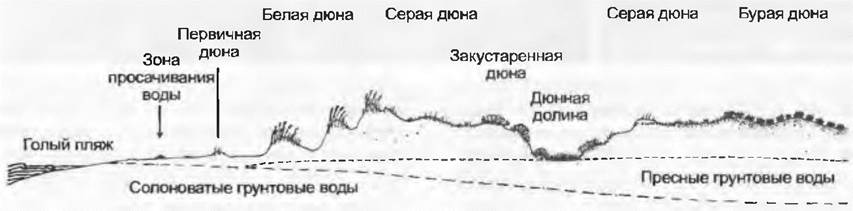
On sandy sea coasts, dunes are formed (Fig. 15.4, Table 15.16). In the still relatively moist and saline areas within the seepage zone, annual plant communities first develop (Cakile maritima, Salsola kali, Atriplex prostrata, etc.), followed by couch grasses with creeping rhizomes (initially Agropyron junceum, then Elymus farctus). The wind shadow they create promotes the deposition of wind-blown sand, resulting in the formation of small "primary dunes". Precipitation gradually leaches salts from these sand accumulations, rendering them suitable for colonization primarily by marram grass (Ammophila arenaria). Meanwhile, dune formation continues. Most dune plants grow upward through the newly deposited wind-blown sand layers, permeating them with roots and forming large clones, thereby making these secondary "white dunes" larger and higher (cf. Fig. 13.24, Table 15.16, K). Once a dune becomes less exposed to wind action (often with new dunes forming seaward of it), it is fully colonized by vegetation, transitioning to the Third Stage—the "grey dune". On North Sea islands, dwarf-shrub communities with Salix repens and Hippophae, or with Empetrum and Calluna, develop on the dunes, whereas pine forests dominate on the Baltic coast. Soil-forming processes continue, leading to the formation of "brown dunes". If the dense plant cover is destroyed, dune formation may start anew (shifting dunes, e.g., on the island of Sylt; also examples from Oregon in Table 15.16, J).
Fig. 15.4. Formation and stabilization of dunes on the North Sea coast: salt concentration decreases and soil-forming processes intensify inland from the sea shore; under natural conditions, "brown" dunes are already forested
On shallow, drought-prone soils in southern regions, dry grasslands form, rich in more eastern and southern plant species (e.g., Pulsatilla, Stipa, Artemisia, Astragalus, Fumana, Teucrium). Where soils are deeper, they are colonized by shrubs (e.g., Cornus sanguinea, Viburnum lantana) and eventually become covered by the aforementioned thermophilous mixed oak forests. On silicate rocks, carbonate-poor sandy soils, and in lowlands also on narrow unwooded coastal strips (locally also on very acidic bog soils), lie the natural habitats of heathlands, whose vegetation is composed of low-growing ericaceous shrubs such as Calluna vulgaris. Particularly typical are the heathlands of northwestern Germany, which developed under an oceanic climate and METABOLISM/18.html">The Influence of long-term anthropogenic impact (grazing, burning) on poor sandy and podzolic soils (e.g., Lüneburg Heath). Here, alongside dominant heather (Calluna), the only woody plant resistant to browsing is common juniper (Juniperus communis). Nowadays, much of these heathland landscapes has been reafforested or brought into agricultural use.
Meadows and pastures are utilized even more intensively by humans. These agricultural lands cover over 20% of the total area in Germany and Austria, forming the basis for beef and dairy farming (cf. 13.9.3). The majority of meadows occupy historically forested sites where trees are prevented from growing due to regular mowing (mow meadows) or grazing (pastures). Depending on soil characteristics and land-use type (cf. Fig. 13.53), various grassland types emerge: nutrient-poor meadows (on poor soils), which are mowed only once a year and lightly fertilized (principal species on lime-poor soils: Agrostis tenuis; on lime-rich soils: Bromus erectus). Lush or productive meadows with diverse species composition (on rich soils) are mowed 2–3 times a year and often subsequently grazed. They require regular and heavy Fertilization (main species: Arrhenaterum elatius in lowlands, Trisetum flavescens in uplands). Wet meadows are generally unfertilized, and their hay is used exclusively as livestock bedding. Their long-term waterlogged soils are dominated by various sedges (Carex)—the so-called "sour meadows"—while periodically moist soils are dominated by purple moor-grass (Molinia caerulea). Dry soils feature shrubby semi-dry grasslands (pastures) with high species diversity comprising Festuca ovina agg., Bromus erectus, and Brachypodium pinnatum. Today, There are also numerous sown, species-poor grasslands dominated by Lolium perenne and red clover. Nearly a third of Central Europe's area and the majority of arable land are currently occupied by intensively managed cultivated land (cropland, orchards, fruit plantations) and associated weed communities (cf. Fig. 13.50, 15.5, P — R).
15.1.2. Upper Montane Forests and Alpine Belt
In the higher mountain belts of the Alps and the Carpathians (upper montane, subalpine, alpine, and nival), a distinct flora comprising a thousand or more vascular plant species thrives, some of which are endemic. Their phylogenetic affinities indicate that most species originated from closely related taxa of the southern European lowlands, while others are linked to the mountains of Europe and Asia, or even to the Arctic. The presence of endemics points to the relative autonomy in the Evolution of the alpine flora and its potential survival on glacial peripheries during glacial periods. Finally, species with disjunctive boreal-montane (mid-mountain) or arcto-alpine ranges, which are currently widespread and numerous, confirm that intensive floristic exchanges took place during the cold Phases of the Quaternary and post-glacial times between the Alps and the Carpathians on the one hand, and southern European (Crocus, Dianthus, Helianthemum) or Asian (Primula, Leontopodium) mountains, as well as circumarctic (Oxyria, Saxifraga) and boreal (Empetrum, Vaccinium) regions on the other. Examples of the European-(montane)-alpine element include Soldanella, Aster, and Geum.
The vegetation of Central European mountains can be categorized into altitudinal belts, or vegetation zones (Figs. 14.44, 15.2). Key driving factors include temperature decrease with altitude, a shortened growing season, increased duration of snow cover, and other mountain climate peculiarities. These belts correspond precisely to the major vegetation zones (temperate, boreal, and arctic; Fig. 14.22) and their associated plant formations (Figs. 15.6, 15.7).
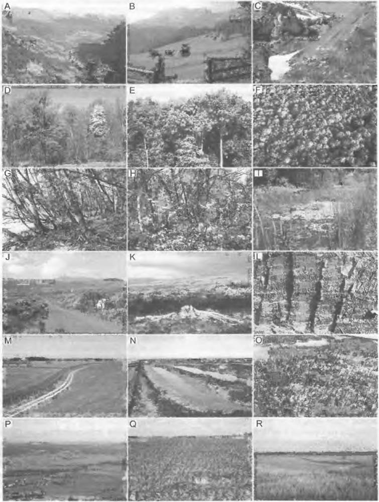
Fig. 15.5. Cultural and natural landscapes of Central Europe: A — altitudinal belts on the slope of an alpine valley (Heiligenblut, Carinthia). The lower section of the mountain forest belt has been transformed into a cultural landscape. The timberline is formed by spruce and larch at an altitude of 2000 m; B — ancient cultural landscape in a mountainous region (Lechtal Alps, 1600 m); C — topography and aspect in the alpine zone promote the development of a highly diverse mosaic of sharply contrasting micro-ecotones. Summer and winter exist side by side (2500 m, Furka Pass, Switzerland). Species-rich beech-oak-hornbeam deciduous forests on the Upper Rhine in horizontal and vertical projection serve as an example of a Central European hill-belt forest ecosystem with high biodiversity (12 tree species); D — spring leaf-out phase; E — mid-summer; F — early autumn foliage coloration. A young (G) and a mature (H) floodplain of flowing water along with a pond (I) illustrate standing-water vegetation (see Fig. 14.36); J — L — Atlantic heathland with Ulex europaeus and a raised bog with peat-cutting traces in western Ireland. An excavated pine stump (K) indicates that a forest stood here 1,600 years ago. A diked marsh (M) and land reclamation measures on the Wadden Sea via dikes (N, O) on the Jutland coast of the North Sea (Ribe Amt, Denmark); P — highly structured cultural landscape in the southern Alsace (Leimenthal); Q — vibrant agricultural land in the Marchfeld near Vienna; R — semi-natural grassland and salt marsh on the Pannonian lowland plain (southeast of Kecskemét, Hungary)
In the Alps, and partially in higher mid-mountain ranges as well, the following altitudinal belts can be distinguished (the lowest one was already described in Section 15.1.1; elevation data are given in meters for the Alps):
✵ plain-and-hill belt: flat and hilly lowlands, up to 300 — 500 m;
✵ submontane (low-mountain) belt: transitional belt of the lowest mountain forests, up to 400 — 700 m;
✵ montane (mid-mountain) belt: lower (600–1100 m), middle (1000 — 1500 m), and upper (1400 — approx. 2000 m) mountain forest zones;
✵ subalpine belt: open woodlands and krummholz, approx. (1700) 1900 — 2200 (2300) m;
✵ alpine belt: closed dwarf-shrub and grassland heaths, up to 2500 — 3000 m;
✵ subnival belt: vegetation patches and scattered individual plants, up to approx. 3000 — 3300 m;
✵ nival belt: snow zone, open areas above the climatic snowline: in sheltered microhabitats, pioneer vascular plants up to 4450 m.
The boundaries of individual altitudinal belts also fluctuate within mountain ranges depending on topography, aspect, and substrate. In the interior parts of mountain ranges, vegetation belts lie higher than on peripheral ranges (mass-elevation effect). The timberline, specifically the upper limit of closed high-mountain forests (English: timberline or forest line), is not a sharp "line" per se, but rather the lower edge of a transitional zone where the forest gradually breaks up, alternating with tongues of treeless alpine vegetation (see Fig. 15.5, A, Table 15.10, B). The line connecting the outermost groups of trees is referred to as the treeline (English: treeline), while the upper limit of isolated dwarf or cushion trees is termed the tree species line (English: tree species line). Collectively, these transitional zones are known as the treeline ecotone (English: treeline ecotone). The ambiguous term "subalpine" applies primarily to this transitional zone, which, owing to the presence of forest, is not yet strictly "alpine," but rather forms a mosaic of both elements.
Mixed coniferous forests of the (oceanic) montane belt are dominated by Norway spruce and silver fir (Picea abies and Abies alba). In continental regions and at higher elevations (mostly on nutrient-poor podzolic soils with a well-developed acidic moder-humus horizon), silver fir recedes. Typical understory species here include bilberry and cowberry (Vaccinium myrtillus, V. vitis-idaea), ferns (e.g., Blechnum spicant), and grasses (e.g., Calamagrostis villosa). In the upper montane forests of the Central Alps, spruce is replaced at higher elevations by Swiss stone pine (Pinus cembra) and deciduous European larch (Larix decidua).
In the subalpine transition zone, open areas between fragmented forests support dwarf-shrub communities with Rhododendron and Vaccinium, shrubby woodland edges, natural meadows, turf patches in avalanche tracks, and shrub communities of green alder (Alnus viridis = A. alnobetula) or dwarf mountain pine (Pinus mugo). Stunted individual trees, deformed by increasing environmental stress, typically form krummholz (elfin timber) alongside these shrubs (this belt is also known as the "zone of the struggle for existence").
Alpine plant communities (Fig. 15.5, C, Table 15.11, A, B), apart from the Alps and the Carpathians, also occur in an impoverished form in the Sudetes. The lower alpine belt is likewise dominated by dwarf-shrub heaths, particularly with Vaccinium species, alongside wind-swept ridges (see Figs. 12.9, 12.13) dominated by the highly resilient Loiseleuria procumbens (a tiny, creeping, heath-like dwarf shrub). Adjacent to and above these are turf-forming plant communities that become increasingly sparse and depauperate with altitude: on acidic soils near the timberline (in and below pastures), mat-grass (Nardus stricta) often dominates; in the upper part of the dwarf-shrub belt, curved sedge (Carex curvula); on carbonate soils, blue moor-grass (Sesleria varia); and on wind-exposed ridges, the cushion sedge (Carex firma). Key plants of screes and rock faces belong to the genera Androsace, Draba, Gentiana, Minuartia, Oxyria, Saxifraga, Silene, and others (see 15.2.11). In snowbeds where snow persists late into the season, nival snow-bed communities develop, characterized by the tiny creeping willow (Salix herbacea) and Soldanella species. Finally, only a few flowering plants reach the nival belt, such as glacier buttercup (Ranunculus glacialis) and Saxifraga species (altitudinal record for the Alps: Saxifraga biflora was found at 4450 m on the summit of the Dom des Mischabel, Canton of Valais).
Last update: 07/08/2026
Editorial and Educational Adaptation: This material has been compiled based on the primary/original source text. The project team performed an editorial review, corrected technical inaccuracies, structured sections, and adapted the content for an educational format.
What was processed:
- elimination of formatting defects (OCR errors, structural breaks, corrupted characters);
- editorial organization of content;
- standardization of terminology in accordance with academic sources;
- verification of factual statements against the original source text.
All mentions of the author, publication year, and origin of the primary text have been preserved in accordance with the source.